|
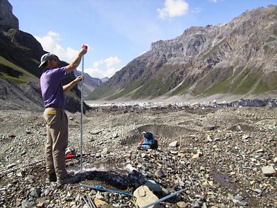
15 July, 1999July 15 Camp is located off to the west of the glacier in a bowl-shaped meadow. The locals refer to this geomorphic feature as a foss. A snowbank drapes the slope adjacent to our cooking area. The snow will provide a source of fresh water. To the north, the view of the Wrangell Mountains is stunning. The lake team has to hike for an hour and a half to get to their field site. It begins with a steep climb up to a grass-covered point, providing an expansive view of the glacier. This is where surveyor Dennis Trabant will work. From there, the route traverses across a steep and exposed talus slope down to the lake. PI Joe Walder and grad student Michelle Cunico do not like hiking this route. It is the only way to get to the lake. Those working out on the ice also have an approximate hour and a half hike to their field site. From camp, this route passes up and over a leteral moraine, across the margin of the glacier which has numerous drainage channels, and onto a medial moraine (which we call the red moraine super highway) which we use as the main arterial to get to the site. The last stretch of the route extends into a crevasse field. Knife-edged seracs which fall away into deep crevasses need to be traversed during this last stretch. I was, naturally, skeptical when I encountered this dicey path on my first trip to the drill site. Seeing driller Joel Harper and grad student Don Lindsay all but skip across these razor sharp passageways did not help. I cautiously made my way through the maze. PI Andrew Fountain insisted that fixed ropes be put in place along some of the more exposed stretches. The hot water drilling site is located in a small bowl with some nearby flat spots. Moulons, crevasses (some filled with water), meltwater streams, and seracs are in and around the drill site. A sizable pool of water is located at the drill site. It will provide a constant supply of water needed for the operation of the drill. It is an interesting work place. Progress in research was made today. Joe Walder (USGS, Vancouver) and Michele Cunico (PSU grad student) managed to lay out 3 pressure transducers along the bottom of Hidden Creek Lake. These will measure the changes in lake level. Dennis Trabant (USGS, Fairbanks) set out survey reflectors on the ice dam. Dennis will soon begin to record the position of these reflectors in order to measure the change in position of the ice dam. Steve Malone (seismologist from University of Washington) and I set up two seismometers. These will record any "noise" generated from glacier calving, crevasse opening. Ideally, they will record some type of pressure wave signal which is generated during lake drainage. Andrew Malm (St. Olaf College undergrad) set up a number of ice radar lines to record the depth to the bedrock so that the drillers would know how far to drill. His measurements showed that the thickness of the ice was 240 meters. Don Lindsay (PSU grad student), Joel Harper (University of Wyoming), and Andrew Fountain (PI from PSU) made a 12-inch diameter hole 150 meters into the ice using the hot water drill. Those at the drill site were feeling positive about making progress into the glacier. Some interesting things occurred during drilling today. In drilling, the hope is to get to the bed of the glacier, access the subglacial hydrology, and lower a pressure transducer to record changes in the hydraulic pressure from the water that rises into the drill hole. At 88 meters, the meltwater which was filling the hole drained. It was inferred that some type of englacial drainage channel had been encountered and drained off the water. Drilling continued and the drill tip met refusal at 150 meters. The bottom was expected to be at 240 meters. A borehole video camera was lowered into the hole to look for what might have drained the water at 88 meters, and to observe what might be obstructing the drill. As the camera was lowered, numerous rocks were observed to be embedded in the walls of the hole. At one point, the borehole camera had difficulty getting by a rock which protruded into the hole. Finally, at about 120 meters, the camera met another protruding rock and would not go any lower. On the way up, a possible englacial channel was observed. Based on these visual observations it was concluded that the glacier at this location was loaded with rocks, pebbles and gravel. It was inferred that as drilling melted its way through the ice, rocks were being dislodged from their icy hold and were accumulating in the bottom of the hole. This is what stopped the drilling. Joel Harper indicated that with so many rocks in the glacier, drilling to the bed might be a difficult prospect. We returned to camp, and began winding down from a long day over dinner preparations. Joe Walder (USGS) radioed us from the lake and told us in a casual manner that the lake level had dropped about four feet. "Good job keeping tabs on the lake, Joe", we thought to ourselves. Given the apparent nonchalant air to Joe's description, we figured that this drop was some kind of a daily fluctuation. We continued on with our pre-dinner discussion. We decided to dine on cous cous and Indian faire. We discussed the nuances of the drilling, and developed a strategy for better drilling results tomorrow. We joked about the gargantuan gas burner which Dennis Trabant had brought for heating water. We called it the volcano. When fired, it could be heard from a few hundred meters away. It shot flames a foot high, and could heat a couple of gallons water in a few minutes. The verbal banter among us lightened the spirit after a long day of work. Camp life was beginning to fit like an old shoe. Joe and PSU grad student Michelle Cunico arrived late back to camp that evening. Joe was more direct with his comments when he told us about the lake this time. "Why are you guys lounging around? With a drop of four feet in lake level, the lake is draining. The outburst flood has started", he exclaimed. Given that we were not planning for the flood to occur for another couple of weeks, this set us into a tizzy…….. _______________________________________________________________ Get Free Email and Do More On The Web. Visit http://www.msn.com
Contact the TEA in the field at . If you cannot connect through your browser, copy the TEA's e-mail address in the "To:" line of your favorite e-mail package. |