|
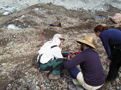
19 July, 1999July 19 This morning we took our time getting out of camp and into the field. The flood had come and gone. The storm of hurry and scurry which had defined the past few days was over. I was already beginning to miss the sense of purpose that the impending flood had brought to our previous work. We ate a huge breakfast. We discussed the data that was collected. We milled around camp. By noon most of us ambled our way out of camp to collect more data. The two PIs remained behind to discuss the outcome of the project and the plan for future research on this project. From his surveying monument (with a stunning view) surveyor Dennis Trabant continued his surveying of reflector stakes which were on the glacier. PSU grad student Don Lindsay hiked to the lake with a survey reflector. One of the goals of the project is to determine the volume of water that was in the lake before the flood occurred. This is an interesting problem. The shoreline of the lake at its highest stand needs to be measured, and the shape of the lake bottom - its hypsometry - needs to be mapped. Knowing the shape and size of the basin, and using calculus, the total volume can be easily calculated. There are a number of ways to approach this problem. Don pursued one of the approaches. He walked the former shoreline of the lake with the reflector, and at a number of locations Dennis Trabant surveyed in his position. This was not a trivial task for Don. He had to fjord a rapidly flowing stream, which drained into the west end of the lake. When this was done, he had to deal with getting around on the south shore of the lake, which was a steep, talus slope. He did manage to get a few points on the south shore. Once the shoreline measurements were made, Don walked into the drained lake basin with his reflector so that Dennis could shoot some points to establish the bottom, and therefore the depth of the former lake. Again, this was not a simple task. The lake basin is loaded with stranded icebergs, some of them quite large, and still calving. Don made wide berths around these icebergs. The information that Don collected is not a complete data set that can be used to map the outline of the lake prior to the flood. However, it will be an important addition to the data that will be collected when other mapping techniques are utilized. The other way to map this empty basin is to use photogrammetric techniques. An airplane will fly over the lake at a fixed elevation, at a constant velocity, and take photographs down onto the lake basin at a fixed frequency. The result will be a series of pictures of the lake basin which will be slightly offset from each other. These can be viewed stereoscopically, from which a contour map can be generated. This will give the shape of the lake basin. The limitation of using this technique to map the Hidden Creek Lake basin is that the bottom of the former lake is obstructed in a number of places with icebergs. This is where Don's survey points along the "real" bottom of the former lake will increase the quality of the hypsometric measurements of the lake. PSU grad student Michelle Cunico, St. Olaf College undergrad Andrew Malm, and I worked the ice radar out on the Kennicott Glacier. Ice radar is a technique which can be used to determine the thickness of the ice, and therefore the depth to the bed of the glacier. If this depth is determined at a number of locations, a picture of the topography beneath the glacier can be mapped. Ice radar works on a very simple principle. A transmitter sends out a pulse of electromagnetic waves, the frequency of which is determined by the length of the antenna. These antennae are extended on the surface of the ground. In this case, radio waves were transmitted - frequencies of 5 to 10 megahertz. A receiving antenna, which is identical to the transmitting antenna, is set to capture the transmission of these waves. Among the incoming (receiving) waves will be those which travel down through the ice, reflect off the bedrock beneath the glacier, and return to the receiver. The travel time for these reflected waves is measured. Knowing the velocity of these waves leads to the determination of the depth to the reflecting surface. Andrew Malm was using an oscilloscope to view the incoming wave impulses. From these, he measured the travel time of the bottom-reflected waves. In one instance he measured a time of 3 microseconds for the transmitted waves to reflect off of the glacier bed and return to the surface. The one-way travel time for these waves to the glacier bed would be 1.5 microseconds. The velocity of these waves through ice is 168 meters per microsecond. Multiplying the time - 1.5 microseconds, times the velocity - 168 meters per microsecond, gives a value for the distance to the reflecting surface - about 250 meters. Andrew transmitted/received signals for a number of locations on the glacier. Decisions have been made about our departure from the study area. PI Andrew Fountain and I will be flying out on Wednesday the 21st to pick up a U-Haul truck at Glennallen (150 miles west of McCarthy). We will drive it back to McCarthy. A helicopter will sling load our gear from camp back to McCarthy on Thursday. We will load up and depart for Anchorage Thursday afternoon. _______________________________________________________________ Get Free Email and Do More On The Web. Visit http://www.msn.com
Contact the TEA in the field at . If you cannot connect through your browser, copy the TEA's e-mail address in the "To:" line of your favorite e-mail package. |