|
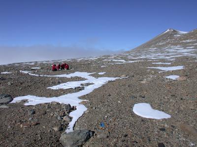
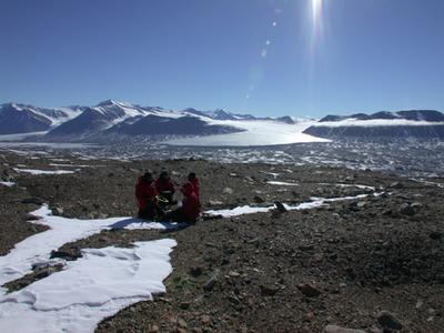
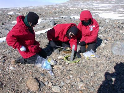
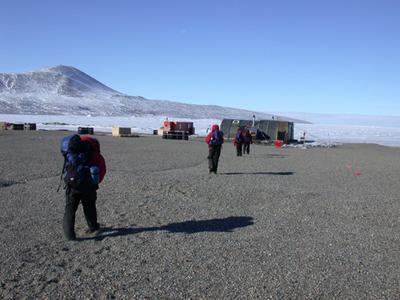
15 December, 2002The second transect done at New Harbor where the Taylor Valley meets the Ross Sea Ice. After getting settled in at the New Harbor field camp, we planned the first sampling of the second transect since it is only about 2:30 p.m.. Scott led the discussion by telling us that we need to get the highest samples first because the weather is clear and we might not be so lucky if we wait. The next decision is which side of the valley to start the sampling. Since we would like to get up to a glacier, we opt to start with the south side where a glacier is close to our collection spot. At least it looks close from the field camp. Dead reckoning Scott, with GPS in hand and on his back since the equipment itself weighs 25 lbs., lead the way as we work our way up and down toward the 300 meter mark. With the valley being 5 miles wide, we have a ways to go. Shortly after leaving the field camp, we come to several steep moraines of loose footing. Some of the team suggest that we go around these, however,our dead reckoning leader goes straight ahead following the coordinates carefully. He is engrossed with his equipment, which is really amazing when one considers where we are. Since we all follow the environmental protection laws for the dry valleys, we walk single file across the valley and up and over numerous slopes faithfully following our GPS leader. Many times we are stopped by one of us exclaiming "look at this one"! We are intrigued by all of the beautiful rocks and ventifacts. Ventifacts are rocks carved into graceful shapes by being blasted by strong winds over centuries of time. The rocks are beautiful! Rusty suddenly shouts, hey look at the aboriginal tools left here! We know he is just kidding, but we do hurry up to see what he has found. Indeed there is a rock that looks just like a crucible where people might have used such a tool to grind grain. We speculate when anything larger than microscopic organisms might have lived on the continent. If you know any scientists, them you can imagine the fun we have activating vivid imaginations. Shortly, Rusty calls out again. This time he has found a bed of moss growing in the soils. Rusty has a strong interest in symbiosis and thinks that there is a chance that symbiosis might be in effect here. We carefully continue. I am amazed at the fabulous observational skills of team members. Time for a snack break and a potty break - well, a Pee bottle break - there are some large rocks that can serve as the "bush" one goes behind to urinate when out on a long hike. Here, we leave nothing but footprints. The women have a new gismo called a Lady J that making urinating easier with out exposing you body to the cold wind. This is a great invention and we all agree that it works quite well! After a snack and some hot soup, we move on to the collection site. Methods are the same as the first transect. Scott stops, says here and we begin to measure the 20 meter square. Again Scott helps us orient North/South, then we rotate keeping the center 10 meter mark at the same spot. (Laurie does this) We then align the East/West line and plant the blue flags. Now we begin the sampling. The wind is picking up and clouds seem to be moving in. We really appreciate that is is not going to be getting darker as it gets later. Why is this true? It is about 8:00 p.m. before we get back to the field camp. Regina begins to cook a great dinner while the rest of us take care of the samples. One can appreciate why you need to be physically qualified by a medical team at home before you are given final approval to come to Antarctica. The hiking we did today is just one example of why one needs to be in good shape. If you are thinking about how you might get to the dry valleys some time, you need to be in good physical shape. We relax with an excellent dinner of pesto pasta and scallops with broccoli. This is a great place. Now it is your turn to think a bit. Can you with your friends write up the protocol (procedure) we used to do the sampling? What equipment will we use? How did we keep the equipment sterile? Why do we need to worry about keeping equipment sterile? How do we keep track of the samples? What label would you make for each baggie? If you need some help, check out the pictures.
Contact the TEA in the field at . If you cannot connect through your browser, copy the TEA's e-mail address in the "To:" line of your favorite e-mail package. |