16 December, 2002
The North part of our Second Transect
It is morning with some fog and blowing wind. Scott suggests that we need to
go to the high point of the north part of our transect before the fog gets
worse. We can almost see where we will be going. The terrain looks really
steep from the field camp, so it is sure to be a tough climb today.
In preparation, one of us boils water for our thermos bottles while another
makes some fresh scones for breakfast. We do eat well here. The packs are
prepared with equipment and the requisite chocolate bars, pemmican (its like
beef jerky) and packets of soup and hot chocolate. Laurie checks to see that we
all have our Pee bottles!
Scott again takes the lead with his dead reckoning skills and the GPS system
guiding our course. What looked like a flat area from the field camp turned out
to be a large series of ridges of loose gravel and rock. Soon we came to a deep
ravine with a riverbed at the bottom. This is an obstacle we had not
anticipated. We might have expected such a river given that the Commonwealth
glacier is close by. The river channel has flowing water in parts and frozen
ice cover over the water in other areas. We stopped to discuss the best way to
get across. There are 5 of us in the team and there are 5 opinions on how to
get across. Laurie, with the shortest stride, had a few requirements that we
all honored. We scrambles and leaped, slid and got pulled by each other - team
work results in everyone getting across followed by comments about how walking
on the sea ice to this point might have been easier. We have no real
complainers in this group.
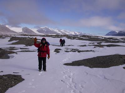
Sometimes a single step would result in a long deep slide down hill, other
times the ground held firm. With packs on our backs, agility was less than it
might have otherwise been. We manage and nobody gets wet. Whew!
We speculate about how many ridges we will climb up, only to find another steep
downhill and another ridge. I lost count after 14 ridges. At one point, Rusty
finds a quicker way to our target area, but the rest of us follow Scott. The
terrain is getting steeper, and finally, it becomes dangerous to walk on the
snow/ice. To slip here would mean a long fall. Eventually we get high enough to
take our sample.
Collectively we decide that we need lunch first, so we perch on the mountain
side moving carefully so as to not slide down while munching on some chocolate
and drinking hot soup.
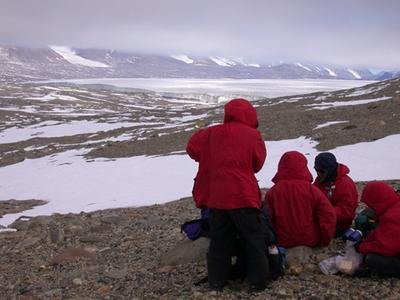
The next site is near two frozen ponds gleaming through the filtered light as
the fog drifts in and out. We set off to get the next sampling site. We now
have a downhill hike. Rusty is most helpful to insure that none of us slip and
fall with our heavy loads. We get to the frozen ponds and are not quite far
enough to sample yet, but we have to stop and explore these ponds. Off come
the packs and we all slide on the beautiful smooth blue ice, then look more
closely along the shoreline which is still frozen solid. Rusty finds more moss
and we all but noses to the ground to see what is finds so interesting.
Then it's off to sample some more. Laurie had declared that we need to be back
to the field camp by 6:00 p.m. so we won't have to have such a late dinner.
This was a great day. We are all comfortably tired and have a wonderful dinner
of steak and cous-cous highly spiced by our wonderful chef supreme - Regina.
Samples are packed away and kept outside. The fog is still present and it has
started to snow lightly. We all comment on how good it is to have completed
the hard part.
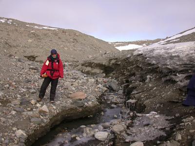
Barb made it down the slope and contemplates crossing the river. We hiked down river to find a good crossing point.

Are we there yet? Have any of you asked that question before? We asked it several times as the slope became more steep the higher we climbed. Now we all watch out for each other. Do you remember why we need to go so high to collect a soil sample for this transect?
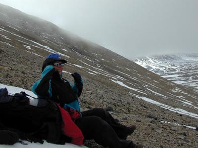
Laurie says here! This is high enough and it's too steep to safely go higher. Scott verifies that we are high enough. Whew! We need a rest. Should we do our regular measuring of the grid here? Is it safe to do so? Is it fair to not do so? What would you tell us to do?

We carefully tossed the aerobie to randomly determine where to collect a sample. Then we dug the soil down to the permafrost using sterile equipment, bagged the soil, labeled the samples and with another toss, crawled to the next spot. Do you think there is any soil here? What makes something qualify as soil? How will our sample compare with any that you might collect where you live?

Scott takes the required hemisphere photo for this site. The fog rolls in and out changing visibility markedly. Can you tell a difference in the amount of light reaching the ground in this photo compared with other hemisphere photos with direct sun? Why do we have fog in this polar desert?
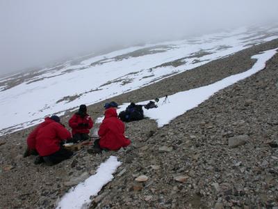
The fog thickens as we work to complete our samples. Regina is using sani-wipes to sterilize the equipment after each sampling. She needs to take off her gloves to get the packages open and wipe everything. She says her fingers are getting much colder this time, but the temperature is the same. Why are her fingers getting so cold? What physical properties are involved here? How can we help her? Are there any questions that you would like to ask me?
Time for lunch. We all made it down from that steep slope and are ready for a hot lunch. Out comes the thermos of water from my pack. I encourage everyone to drink lots! The packs are heavier now with the soil samples divided evenly among us - almost. Scott has the GPS, so Rusty carries more than the rest of us. Thanks Rusty. Doesn't this look like a lovely spot for a picnic?
The fog begins to lift as we hike toward the pond spotted by Rusty. This pond seems to be near our next sampling site. Scott agrees, so Rusty leads the way. He was most helpful as we made our way down the steep part of our hike. Caution prevents accidents. Everyone made it down with no tripping or slipping. Is this beautiful or what!
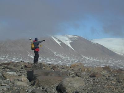
Scott is showing us the direction he want to go for the next sampling site. Lucky for him that the pond is in the same direction. It appears a turquoise blue in the distance and we all want to check it out. Why do you think the color is different from ice cubes? Can you see the pond in any of these pictures?
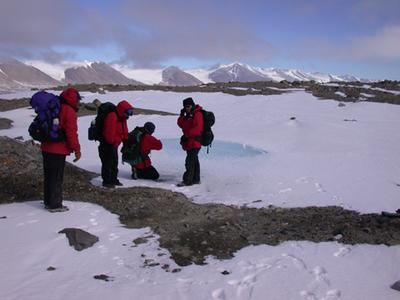
We made it to the pond. Look closely near the front part of the pond in the gravel area - we find what looks like moss and maybe some other things growing. Here we go - each of us has a bunch of questions about the stuff we see. Soon the backpacks come off and be are distracted for a while from getting to our next site. Here are some questions for you. If you are the Principal Investigator what would you do with your team? Can you let them collect a sample here? How much time can you allow for this stop? Is it safe to let your team go on to the pond ice? What if it cracks? Is it safe? What is your responsibility?

Look what we found! What do you think it is? Where did it come from? How did it end up like this? How long has it been here? Can we take some of it to look at under our microscope?
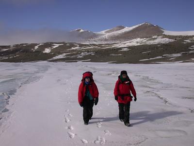
After collecting the second grid of samples and with packs loaded with soil samples, we head back. We choose to walk back on the sea ice this time. We walk close to shore where we have solid footing and don't sink deeply with every step like we did on land. Do we need to walk single file here? Why or why not? Is it safe to walk here? What do you think? Talk about your ideas with your friends and let me know what you think.
Contact the TEA in the field at
.
If you cannot connect through your browser, copy the
TEA's e-mail address in the "To:" line of
your favorite e-mail package.
|


