|
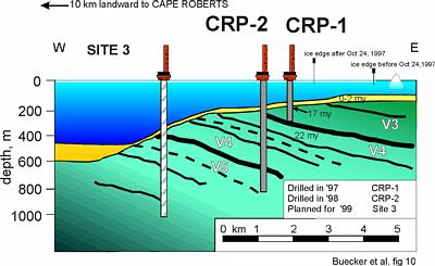
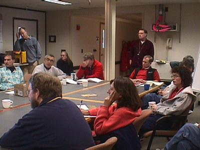
2 December, 1999NEWS FLASH: I just got word that I may be on a flight back to New Zealand tomorrow morning. (Remember, stay loose in Antarctica.) This is still unsure as the weather here is overcast and the southbound flight from Christchurch might be cancelled. If I fly tomorrow, this will be my last journal from the ice. I will post a journal from New Zealand to let you know how the flight went. If not, I will post one last journal from Antarctica tomorrow. B.S. The on-ice phase of the Cape Roberts Project is just about over. There was a get-together, a kind of Bon Voyage party, for the members of the CRP Team at Scott Base last night. Peter Barrett, Chief Scientist on the project, gave a short speech summarizing the history and accomplishments of the project. Yesterday, a science meeting was held in Crary Lab during which each science group gave an overview of their findings and interpretations of the data to date. Each scientist has contributed to an Initial Report, which is to be completed before they leave the ice and will be published soon after. These are the events that are bringing closure on the most ambitious drilling project ever in the Antarctic. It has been a three-year project that has involved hundreds of people from many parts of the world. What were the results from CRP-3, the last year of drilling? Many of the findings that can be gleaned from the data collected will not be known for months or years from now after scientists have had time to analyze the tremendous amount of data generated by CRP-3. The information must also be compared to the other years data and information from other sources. However, there are some conclusive findings that were presented at the summary meeting that tell of the success of CRP-3. As a reminder, the original science goals of the project were to answer these two questions: "Did the ice sheet grow and decay on Antarctica, with attendant changes in global sea level, prior to the earliest Oligocene 34 Ma ago, when it is widely believed the first extensive ice formed on the continent?"; and " At what time did the continent begin to rift to form the Ross Sea and the Transantarctic Mountains?". The scientist who proposed the project believed that in order to start to answer these questions, they needed to study rock deposits from that time period between the Oligocene geologic epoch (24-34 mya) and the Eocene epoch (34-55 mya). They determined from seismic studies that the Cape Roberts area would be a likely place to drill to reach these rocks. They proposed to drill three holes, each one drilling in rocks overlapping in geologic time with the previous one in order to produce a continuous rock record of the time when Antarctica changed from a relatively warmer climate to its present cold climate, about 34 million years ago. It was hoped that the data from CRP-3 in 1999 would help unlock the history of this critical time? The CRP-3 drilling was a great technological success. The drilling went to a depth of 940 meters, a record for drilling in Antarctica, and went a long way towards perfecting the task of sea ice drilling in these difficult conditions. The knowledge gained will greatly benefit future drilling here and in other ice-covered locations around the world. Scientifically, a lot has already been learned from the rocks of the drill cores. The scientists feel that the rocks at the top of CRP-3 may be the same age as the rocks at the bottom of last years drilling, CRP-2. They think there is about a 20-meter overlap. They are also confident that the rocks at the top of the hole are Oligocene in age, about 32 million years old. This was determined primarily from studying the microfossils found in the rocks. Below the top 100 meters or so, the number of fossils diminishes greatly and the age of the rock is harder to determine. They need to wait for other dating information, paleomagnetic and radiometric data for instance, in order to date these rocks. They know the age of the rocks is getting older as they go down the hole, perhaps back to the very start of the Oligocene, the beginning of the cold period in Antarctica, but are not sure if they have drilled to the Eocene. The rocks do indicate change in the climate, however. The rocks from the middle to early Oligocene indicate the existence of low diversity, beech type vegetation, similar to tundra areas in Canada and Alaska. The sediments seem to indicate glacial advances and fluctuations that affected the type and distribution of plants. But did they get to the Oligocene/Eocene boundary, that critical time in Antarctic climate history? The consensus is probably not. As they drilled deeper, the rocks of the Oligocene were getting older and tantalizingly close to the Eocene. Then they suddenly drilled into rocks that were much older, skipping over 300 million years of time, to the Devonian period. This was quite unexpected! No model of the rocks considered by the geologists in the project predicted these rocks to be here. This was a new finding and forced the scientist to reconsider their understanding of the geologic history of the Transantarctic Mountains in this region. Much of the summary meeting and many casual conversations were consumed with speculating on alternative models of the formation of the rocks in the area. It will take many years and probably more drilling and exploration to answer the questions that the discoveries of CRP-3 has forced the scientist to ask. So no, CRP-3 did not reach the goal of getting a continuous rock record of the Oligocene/Eocene boundary. The questions originally posed in the science plan are still left unanswered. But progress has been made toward achieving the answers. Perhaps more importantly in the scope of human scientific understanding, our knowledge of the history of this part of the Earth has taken a leap forward and CRP-3 has created a entire new set of problems and questions to be answered. Science could not be better served.
Contact the TEA in the field at . If you cannot connect through your browser, copy the TEA's e-mail address in the "To:" line of your favorite e-mail package. |