|
|
25 January, 2004
Day two without ice, and it is a cold gray day. Visibility is poor
and we are running with seismic streamer all day today. The fog has
moved in and we have had snow most of the morning. The decks are
white, but there is very little cheer on the Palmer. The change in
weather has made everyone a bit quieter today. Doing the marine
mammal observing is parcticularly difficult with the low visibility.
The wind has started to pick up so the swells are often white capped.
When we are looking for whales, we look for the spray from the
blowholes. In calm seas these are much easier to distinguish.
We have six guns in the water and seismic is the order of the day.
We are currently in the open water to the east of B15A making
transits of 40 nautical miles or more before we turn to establish a
new shot line. Along these lines we hope to locate faults and
volcanic formations. By making parallel lines to one another, the
scientists can orient the direction of these features relative to one
another. They can extrapolate a fault's direction to points beyond
the collected data to estimate the direction that it takes on the
Antarctic Continent and out into the ocean.
When we are taking seismic data the watch goes much more quickly. We
have to log longitude and latitude, sea floor depth, ship speed, ship
direction, magnetic data, gravity data and shot point every five
minutes. Every fifteen minutes we also have to record shot point,
and confirm that the data collection for the multichannel streamer is
operating properly. At thirty minute intervals, we have to record
longitude, latitude, and shot point on a real-time graph of the
seismic data. Every hour we rotate between watch station, marine
mammal observation and beam editing. The variety does make the time
go faster.
Stuart Henrys and Huw Horgan have been working with electronic techs
and marine techs to insure that we are collecting the best data
possible. With their help and that of Mark Weiderspahn, UTIG, they
have been working to identify any problems that would contribute to
"bad" data. "Bad" data points are present in all data collected, but
through thorough analysis, the affect of these points is minimized in
the final analysis.
The scientists are always looking over the preliminary data, trying
to identify trends and features that will help them to understand the
nature of the crust. When they find promising data, they use
specialized computer programs to re-graph the data to allow them to
identify subtle variations that are much more difficult to see in the
initial plotting.

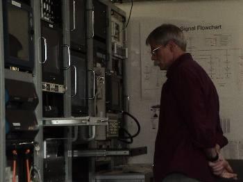
Mark Weiderspahn checks over the electronics for the seismic streamer.

Contact the TEA in the field at
.
If you cannot connect through your browser, copy the
TEA's e-mail address in the "To:" line of
your favorite e-mail package.
|
