|
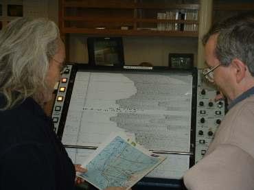
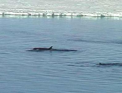
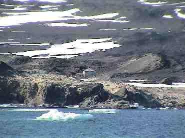
1 February, 2004We had completed using the single channel streamer sometime during the night and we were now towing the multichannel streamer. We were using two air guns rather than the larger six gun array that we had used in the open water. There was still concern about the ice damaging the streamer, but there was a high degree of comfort among the scientists and marine techs that the ice that we would encounter today would not be a big factor. We were adding shot lines to supplement ones that we had shot yesterday. Using the multichannel streamer produces data that has much greater resolution making it easier for the scientists to identify and recognize features in the crust. The scientists are able to view the seismic data in real time by looking at a thermal plotter that is generally called the "EPC" on the ship. The EPC looks like a picture made of thin lines and squiggles. To the geophysics patterns represent folded regions of rock in the crust, volcanic features, faults, or other more complicated structures. The trained eye can quickly recognize an unusual feature, and then there is often a conference of the minds where ideas are shared and hypotheses are hatched. Over the last few days there have been many conferences over the EPC as the scientists discussed their observations and used the plots to select new shot lines that would give them more information about the direction and size of the features that they observed. It takes days to formally process the data. The data is collected and stored with time and geographic data encoded with it. These files are saved as the data is collected and the organized by the time they were collected. All the time information is recorded using GMT, Greenwich Mean Time, which is thirteen hours behind ship time. At midnight GMT each day the data is backed up for permanent storage. Twenty four hours later, the data can be processed using special computer software to get a more detailed look at the data. When the scientist leave the ship their will take the data with them and this will be the basis for published papers and further research by them and others for many years. The weather has been glorious, clear and with light winds. A strong wind to the north would help move some of the fast ice out past B15A and B15K, but that doesn't appear to be in the forecast. Through the morning, the ship has been making parallel shot lines that start on the ice edge on Ross Island and extend to the eastern ice edge of McMurdo Sound. As we approach the ice edge, it is not unusual to see pods of Orcas moving up and down the edge. The ship's navigators are always careful to keep the whales at a distance much greater than the protective radius for marine mammals when we have air guns in the water for seismic. At about 9:00 AM ship time, we entered fresh clear sea ice about one to three inches thick. The only open water was at the edge of the old sea ice and in the wake of the ship. As we approached the old ice, a pod of six Orcas was sighted. They were well out of range, so we just kept track of them. As the ship began its turn, the Orcas appeared to move toward the open water in our wake. Within minutes, we had whales within the protective zone and the MPC; Ashley Lowe was contacted and firing of the guns stopped. Everyone rushed to the decks to see the whales since they were so close. Little did we know on bridge, a problem had occurred with the computer data logging system, and not only were we not collecting seismic data because of the whales, no data would be collected for about thirty minutes until the computer system was online again. The electronics and network staff kept the scientists informed of what was going on as they made a quick restart of the system. The scientists decided to pull in the streamer, for the time being. We would continue to do multibeam sidescan sonar for the remainder of the day. As we traveled back and forth across the sound we had spectacular views of Ross Island and the east coast of McMurdo Sound. Our course took us so close to the cost of Ross Island that it was easy to identify Shackleton's Hut. Shackleton was a British explorer who attempted many Antarctic firsts. He is known for his attempted Antarctic crossing from the Weddell Sea on the west coast to Ross Island on the east. During the expedition, the ship was trapped in the sea ice and destroyed. He and his crew were able to make it to Elephant Island where he and a rescue party eventually made an 800 mile crossing to South Shetland Island were a rescue ship was secured. After about two years the crew was rescued. All members of the crew survived. From the ship, we could see the red coats of visitors as they looked around outside of the hut. The hut is a historical site, and efforts have been made in recent years to make historically appropriate repairs to the structure that has occurred over the years. --

Contact the TEA in the field at . If you cannot connect through your browser, copy the TEA's e-mail address in the "To:" line of your favorite e-mail package. |