|
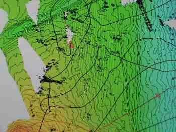
4 February, 2004The sun is circling lower on the horizon each day. After midnight the sun taunts us with a dusky display of deep blue and purple, the prelude to the reds and oranges of a glorious sunset, but the sunset never comes. We are destined to have twenty-four hours of light until the cruise ends. The first sunset in this part of Antarctica will not be until March. Our internal clocks strain to make sense of this night less situation. We great each other throughout the day with a good morning or a goodnight, with little regard for the clock that keeps ship's time. All that matters is if we are getting up or going to bed. Meals have become times to make human connections and gain nourishment. One day soon the sun will serve as conductor to direct a symphony of sleep and wake in harmony with light and dark on this cold continent. Today was spent filling in the holes in the multibeam data. The ice is constantly changing and the seafloor maps that we have made using the multibeam sidescan sonar since the start of the cruise have missing data because of this. The data "holes" are created when the ship had to navigate around icebergs or large ice flows. The missing data appears as white patches in the otherwise colorful contour maps that are produced from the sonar data. It took a cooperative effort between the ship's pilots and the scientists to determine the day's impromptu away points that would complete the coverage of all of the sonar map data. Using these maps the geophysists will determine the best lines to transit to use the seismic equipment to delve deeper than the contour maps take us, into the upper layers of the Earth's crust. The ship's course is constantly monitored using GPS (Global Positioning Satellites). Every sidescan sonar pulse, and every seismic air gun shot is recorded and stored aboard the ship's data acquisition system with a precise location stamp given by the GPS. Using the GPS we can return to within less than a meter of a location that had been mapped earlier. We know exactly when the data was collected as well using precision clocks that record the GMT, Greenwich Mean Time. The combination of time and position stamps on each data set measured and collected by the experimental equipment makes the data that is recorded during the cruise very reliable and precise. The preliminary data from the sidescan sonar is manually edited file by file in a process called ping editing. The sonar works by producing a sound pulse, a ping that is directed downward from the bottom of the ship to the seafloor. The sound is reflected back up to the moving ship. One hundred and ninety one (191) receivers on the bottom of the ship detect the echoed sound. The scientists call the information that the receivers record a beam. One ping produces 191 beams. Each beam records information about distance to the seafloor that is then used to create seafloor contour maps. Ideally, each ping would produce a perfect data set of beams, but this does not occur for a variety of reasons. The most common causes of errant beams is rolling and pitching of the ship in rough seas, noise caused by moving through the ice, and changing of the position of the ship during turns. Before the ping data can be used for mapping, we edit each file. About twenty-four files are produced each day. We look for the errant beams and delete them from the data that will be used in the final mapping. The original data set still has the "bad" beams and will be saved for future reference by the scientists. The ping editing process is slow and methodical. We follow general guidelines, but it is primarily through experience that you become efficient and accurate at ping editing. After each file is edited, a map of that data is printed and compared to the raw data. Chris Linden, multibeam support, and Marcy Davis, from UTIG catch any glairing errors made during editing in "quality control". Each of these individual files is then combined to form large finished maps of the data. The ice has been cooperative. We should have all of the holes filled in the multibeam data by tomorrow. Traffic in McMurdo Sound is picking up. Container ships with supplies for the winter and next year are making their way into McMurdo port. The end of the summer in Antarctica means the end of the science field season. Our science crew is scheduled to be on the second to last flight out of McMurdo. The population at McMurdo will be reduced to the winter overs. Everyone that has not left on the last flight is in Antarctica for the winter. It will be October before the next flight returns.

Contact the TEA in the field at . If you cannot connect through your browser, copy the TEA's e-mail address in the "To:" line of your favorite e-mail package. |