|
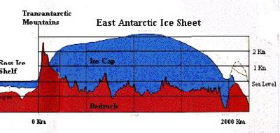
20 December, 1996In the Journal picture for December 14, I am standing next to a rod that marks the current geographic position of the South Pole. Somebody noticed that there was a similar looking rod on the left side of the picture and asked me to explain why it was there. The rod in the background marked the position of the pole last year. In fact, there are a series of similar rods that almost look like a row of fence posts. They each marked the pole's position in a previous year. I've included a sketch to help explain why the pole moves and why there are so many markers. Antarctica is a continent of extremes, it is the coldest, windiest, driest, least populated, and the highest. The estimated average altitude is 7500 feet. The value is so much greater than that of other continents because a significant portion is mountainous and it is covered by over one mile of ice. The ice sheet is thickest in the interior of the continent and thinnest at the edges where the land and water meet. This difference in thickness causes the ice to flow toward the edges of the continent carrying everything that is on top of it and can move as much as 100 feet in a year. Every year a marker is placed at the current pole position but the previous years markers are not removed. If this were to continue, there would be a string of rods from the pole to the ocean in less than 100,000 years.
Contact the TEA in the field at . If you cannot connect through your browser, copy the TEA's e-mail address in the "To:" line of your favorite e-mail package. |