5 December, 2000
Where's the Dome?
I've had people ask me, "What's it like inside the dome?" I think some have
seen pictures of the dome at the South Pole and think that is what Siple
Dome is like. The dome at the Pole is a man-made structure that houses much
of Amundsen-Scott station.
Siple (SIGH-pull) Dome is a ridge of stable ice located between Ice Streams
C and D. It was named for Paul Siple, a scientific leader during the early
years of U.S. involvement in Antarctica.
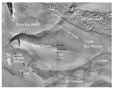
A. In this image you can see the ridgeline or divide that runs along the crest of Siple Dome. Even though this feature is evident in a satellite image, the surface looks absolutely flat from the perspective of the ground. Even when I traveled out to the J-hole at 32 km south, it was very difficult to detect any slope.
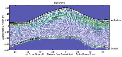
Now this looks like a dome! However, the vertical dimension is exaggerated about fifty times. This image was produced from radio echo-soundings (RES). Both low frequency and high frequency radar were used to reflect off the bedrock and internal layers of ice. It shows a slice through Siple Dome that runs roughly north and south. It is the same line along which the drill sites are located. Notice that the bedrock beneath the ice is a few hundred meters below sea level. This is true for much of the West Antarctic Ice Sheet. Image credit: Both images are from Flow History of Siple Dome www.geophys.washington.edu/Surface/Glaciology/PROJECTS/SIPLE/siple.html
Contact the TEA in the field at
.
If you cannot connect through your browser, copy the
TEA's e-mail address in the "To:" line of
your favorite e-mail package.
|


