|
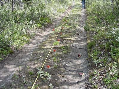
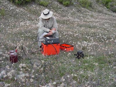
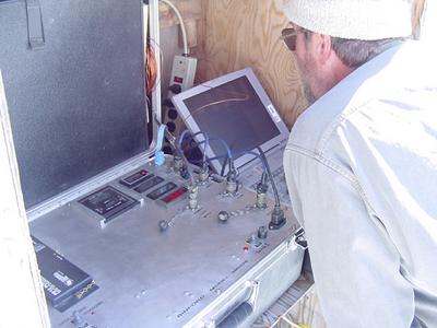
22 July, 2002Greetings........ Bob Bigl bored the hole today that I will use for my project. It is located on a relatively flat portion of the glacier that will allow for fairly easy use of ground penetrating radar. Dr. Baker and I plan to head back up on the glacier later tonight to see if the drilling equipment has been moved. If so, we will head up on the glacier first thing in the morning and do some testing with GPR and the weights to determine how best to proceed. If the drill equipment hasnąt been moved, then we will collect some GPR data on a site that Kendra has been working on to image the top of buried ice. Today I went out with Dr. Baker, Kendra, and Darren (a REU student) to collect some seismic data. This is a continuation of work that has been ongoing for several years. Dr. Baker is attempting to find the depth to bedrock beneath glacial outwash debris. We ran two separate lines about 300m long each at two separate locations. This data will help reveal how the depth to bedrock varies throughout the Matanuska River valley. Seismic data is collected by measuring the time it takes for energy (similar to sound waves) to travel underground and bounce or łreflect˛ off of boundaries in the subsurface. Once the energy reflects, it returns to the surface where it is recorded using instruments known as geophones which are firmly planted into the ground on metal spikes. Seismic energy can be generated many different ways, but we made ours today by sharply and repetedly striking a sledge hammer against an aluminum plate that is seated into the ground. The location of the generated wave (known at the łshot location˛) is then moved along the set line when the plate is struck again. This process continues along the entire length of the line. We were using 12-m intervals between shot locations. The geophones collect data by generating an electrical charge when the vibration from the wave (or any other source) reaches them. Several times today we had to wait for airplanes to pass so the the noise from them didnąt interfere with our data collection. Inside the geophone is a coil of wire suspended on springs. Inside of the coil is a magnet. When the wave reaches the geophone the magnet moves up and down relative to the wire creating the current that is recorded and ultimately used to determine what types of materials are beneath the surface. Another glorious day on the Matanuska....... Life is Good, DT
Contact the TEA in the field at . If you cannot connect through your browser, copy the TEA's e-mail address in the "To:" line of your favorite e-mail package. |