|
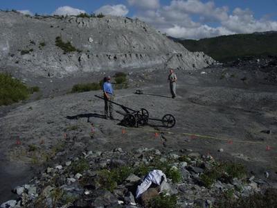
23 July, 2002Last night, Dr. Baker and I walked back up on the glacier to the drill site to see if the drill rig had been moved from the site. It hadnąt, so we decided that I would help Kendra Pyke, one of Dr. Bakerąs students with a project she is working on. She is using Ground Penetrating Radar (GPR) to attempt to locate the top of buried ice in a debris area off the glacier. Please refer to my project description for an overview of GPR. She worked in the same area last year, and is looking for differences between then and now. The study area Kendra is using is approximately 30m x 20m. We ran data collecting lines across the short axis at 2m intervals. I have attached a picture that shows a sled that is used to hold the transmitter and receiver in fixed locations as it is pulled across the work area. There is an odometer attached that signals when to send an impulse. This greatly speeds up the data collecting. After finishing collecting data at Kendraąs site, we loaded up the gear and headed up to the drill site on the glacier. The gear included a field hardened computer for collecting GPR data, a car battery to power the computer, the GPR antennae and fiber optics lines for transmitting data to the computer, metal weights to be lowered into the hole, and line to support the weights. This was all strapped to three separate frame packs and Kendra, Dr. Baker and I hauled it all up the glacier. We set 100MHz antennae at opposite sides of the hole (2m apart) and collected some baseline data. We then lowered the weight into the hole slowly while continuing to gather data. We were able to get good returns the entire length of hole. We then pulled the weight out of the hole and marked the line at 10m intervals for a total length of 96m. After this, we lowered the weight to a depth of 10m and ran a profile 18m long 1m down glacier from the hole. We repeated this process for each of the 10m intervals including the weight sitting at the bottom of the hole. We again pulled the weight out of the hole and ran two separate profiles with the hole empty. The profile of the empty hole will show any interference in the ice (for instance debris bands or water conduits). This data can be subtracted from the data with the weight at different depths to help improve the clarity of the image. Dr. Baker will process this data, and we will discuss how to proceed with the project from there. As I type this, it has started to rain........ the first weąve had since Iąve been here. Looking to the west, the sky is fairly clear, so I donąt think it will last long. Life Is Good, DT
Contact the TEA in the field at . If you cannot connect through your browser, copy the TEA's e-mail address in the "To:" line of your favorite e-mail package. |