|
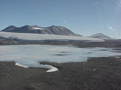
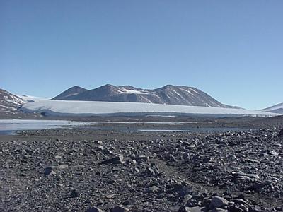
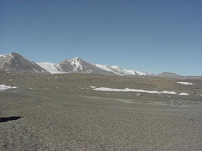
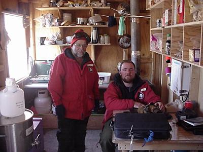
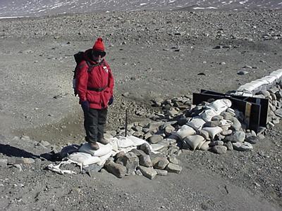
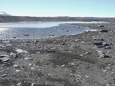
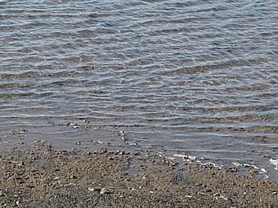
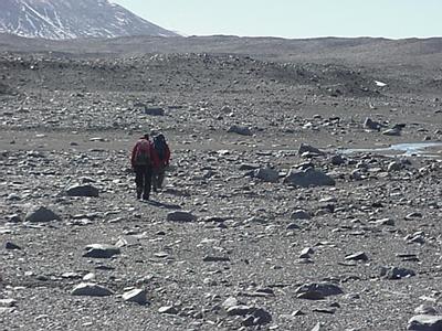
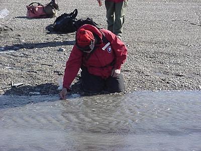
10 December, 1999Friday December 10, 1999 This will be a difficult day for it will mean saying good bye to a number of wonderful, friendly, talented and unique people, and to say good bye to Lake Hoare and the Taylor Valley. I woke up at 0300 hours out of a sound sleep thinking I had over slept my flight. By the time I found my glasses and looked at my watch, and realized I had not, I was pretty flustered. Couldn't sleep so went through the stuff I would need at Field Site 6 (F-6) which is located on the other side of the Canada Glacier, further down valley and therefore closer to the Ross Sea. I feel back a sleep and woke up about 0600 and stayed up to pack all my clothes. I am leaving the field today. I got to the main camp about 0645 and had a chance to chat privately with Camp Manager Rea Spain, and 18-year veteran here on the ice. Rae does everything and does it well. Her jobs go from ordering all supplies (Oreos to oscillosopes);emptying and retrograding all wastes (stool to food wastes); communication with McOps and all field parties in the valley; flight coorinadtior for all helicopter work (Helocpoter is the only way to get into the dry valleys) and cooking the evening meal for anywhere from 4 to 15 people. She does all this with a smile and a sense of humor, but you do know she means business and that basically her word is law. She knows her stuff and runs the camp with her primary concern being keeping people healthy and safe and doing good science. It was a pleasure and an honor to work with a woman with such outstanding abilities. Michael Gooseff (the fellow I have been working for this week) and Ethan Chatfield (a graduate student who like Mike is part of the "Stream Team") showed up about 0745 and we began to bring all our supplies, and all my gear to the staging area. The plan called for a double flight. Mike and I would go first and then Ethan and a new hydrologist from USG named Jon Mason would go on the second flight. The helicopter was right on time so I said my good byes to Kathy and Rae. We loaded the Chopper with all it could carry and we were off. It is about a 6-minute flight up over the Canada Glacier and then down onto this broad desert stretching probably 2 miles wide across the valley floor and at least another 12 or so miles to the sea. Then right in front of us was Lake Fryxell, another glacial lake much like Lake Hoare, which was showing signs of serious melting. This lake is fed by two major glaciers the Canada and the Commonwealth and a couple of minor ones. On the far northern bank of the lake was Lake Fryxell Camp then off about 2 miles further down valley on the southern side I could see F-6, a wooden box that served as a kitchen, dinning area, storage area and laboratory, and three tents. My home for the day and Michael's, Ethan's and now Jon's home until the end of February. (Michael has been there since October 20 and Ethan since November 4th.) Once we got on the ground and the copter returned with Ethan and Jon, Michael showed Jon around. I just sat and starred at the scenery, at least 10 glaciers, some miles long, about 27 mountain peaks with an ice blue lake to my left and a desert to my right and running out in front of me eventually to the sea some 12 miles away. I am in total Awe! We had a sandwich and some chocolate and some water for a snack. We then took a couple of chocolate bars and some trail mix, we filled our water bottles and grabbed our pea bottles and took all this stuff and put in our backpacks. Michael and Ethan grabbed the equipment we would need today: conductivity meter, temperature probe, a GPS meter and lots of sample bottles. The mission was to walk out until we found Akine Stream, a stream of Commonwealth Glacier melt water that eventually finds its way to Lake Fryxell, and do a synoptic survey. In English that means to take GPS positions and at that point and measure temperature, conductivity and collect samples for cation, anion, nutrient and pH analysis. Michael estimated that the water was probably a mile or so down valley. Since myflight was at 1645 hours Mike decided that we should be back at F-6 by 1600 hours. It was 1100 hours when we left, that gave us about 3 hours to find and start sampling the stream and two hours to get back to camp. The trip out of camp down valley was amazing, it has to be what Mars is like; sand and rocks, cold, dry as a bone with no vegetation at all. To left and right mountains, I would guess are anywhere from 500 - 1800 meters tall, each with glaciers running down round them on their way to the desert floor. Some of this melt water will reach Lake Fryell, but most of it will simply ablate into the atmosphere that has a relative humidity of around 2% to 10%. The terrain was very difficult to travel for the sandy areas were glacial moraine and were composed of stones and dust. The topography was a series of little hills and valleys. As we walked I noticed a series of "gullies", maybe 12" wide and in some cases 30' long. If you followed these gullies out they always came in contact with two others; these seem to form a pattern. I asked Mike what they were he told me they we frost cracks and it is those that give the ground that sort of polygonal appearance from the air. Wow! The stream front was actually about 1.25 miles from camp over very difficult terrain so by the time we got there I knew I had been doing some serious hiking. We found the water at a spot known as Three Glacier Hole. It was probably 20m X 30m X 8" deep. In it were great mats of algae. You could see these in the dried up stream bed also, there they looked like greenish gray corn-flake-like pieces of matter that were spongy not brittle in nature (We had followed the stream bed down valley as it meandered around the ridged landscape. We walked along the "shore" of it to prevent contaminating the sight of future water flow be it tomorrow, next week, next month or 100 years from now. In some spots this stream bed was 10 meters wide) These algae mats had been dry and frozen for probably at least a year in some spots and depending of meteorological factors in the area some of the "tributaries" of Aiken Stream may have been dry for centuries. What happens is that the glacier in many cases miles long and wide and miles away, therefore experiencing different weather and temperatures conditions responds to those conditions. Sometimes this results in a lot of melt water yet at other times very little. As this melt water moves away from the glacier it will evaporate because of the extremely low humidity, therefore reaching some tributaries and not others. The ceaseless wind also plays a major role by shifting the base of the stream bed and making it easier or harder for the water to flow in one direction or another. We took our first samples and ran our tests at Three Glacier Hole and then proceeded up stream taking 3 more samples over the course of the next mile or so of stream. In some areas the stream was relatively narrow and deep, and in some places there was a broad and beach-like with numerous rivulets, all very shallow, bringing water to a narrower and deeper spot down stream. We got to within, I would guess, a 1/2-mile of the glacier front, but, time constrains made us turn around. The trip back was no prize for we followed the stream bed back toward F-6 simply to get a second view of the area, just in case we missed any important or interesting/significant feature on the way out. By the time we got back to camp Ethan and I were serious-time "bringing up the rear". That's only fair for we were the oldest and the youngest, and that just goes with those territories. We arrived to camp at 0355, great planning on Michael's part. We sat and chatted for 20 minutes then I went outside to put on my ECW gear, you cannot fly without it on, even if it is relatively warm. Once dressed I just laid on my luggage, snuggled up in my parka, waiting for my "taxi" to arrive, while Mike, Ethan and Jon started to run the lab tests on the samples. Remember the kitchen/dinning room /living room, well it had to be converted to the laboratory before any work could be done. My chariot did not arrive until 1720 hours, you don't questions why; you just say thanks for the "lift". It arrived in a blaze of blowing sand. The helicopter was the big "212". It can carry up to 8 people and quite a bit of cargo. As is always the case when the helicopter arrives you lay across your luggage with your hood pulled completely around your face. Barb was on board along with the pilot and helo-tech, "baggage/person handler". I waved good bye to the guys and to the dry valley. As I did, I knew I would never see this place again, but I also knew that I was probably one of less then 1000 people to have ever seen this place at all. I left with a proud, but saddened heart and with mega-tears in my eyes. No time to be depressed though for the pilot, upon leaving F-6, flew up and over the top of the Commonwealth Glacier. It looked like we were heading toward Marble Point a refueling sight. We wove in an around breathtaking mountaintops and over tremendous field of ice and snow. Finally off to the right I could see Mt. Erebus, and I knew my guess was correct. We were headed to Marble Point. As we came down out of the mountains a broad glacier lead almost to the sea, ending abruptly on a spit of land that had two small buildings and four fuel tanks. Welcome to Marble Point. We did not refuel but picked up 3 more souls for a flight back to McTown. With these three passengers came so much gear that the entire right rear of the helicopter was stuffed as were the 5 passengers. In fact ,as we headed out of Marble point over the Ross Sea the helo-tech commented to the pilot that it had better be a quick trip (about 35 minutes) or they might have to supply oxygen to the "sardines". Cute, but who cares, a shower and a bed awaits me when I got back to McTown. As we approached McTown a strange sit caught my eye. All the buildings that made up the ice runway were lined up in single file, it looked like a circus train. During the night and tomorrow, bulldozers would pull these buildings, remember they are all on "skis", to thicker ice at William's Field. Another thought, that means no more wheeled aircraft can land which means our flight home will be a LC-1130 Hercules with skis. Significance is that will be almost a nine hour flight as opposed to the 5 1/4 flight down on the C-141 jet. Worry about that another day. We touched down at 1900 hours, and by the time all the gear was offloaded and I got to my dorm it was almost 2030 hours. A shower and to bed. It will be great not to smell bad and to have had enough rest to realize I smelt bad in the first place. Good night. Penguin Pete the Polar Man
Contact the TEA in the field at . If you cannot connect through your browser, copy the TEA's e-mail address in the "To:" line of your favorite e-mail package. |