|
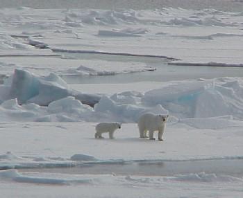
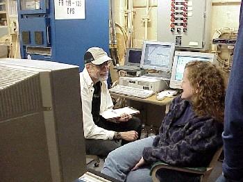
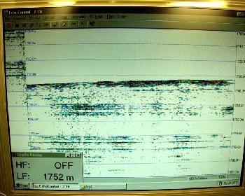
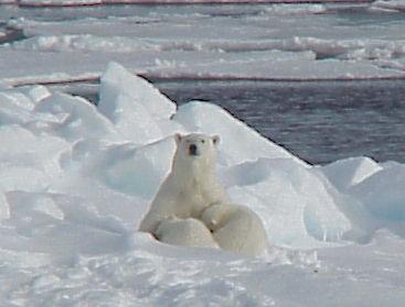
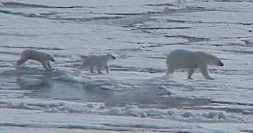
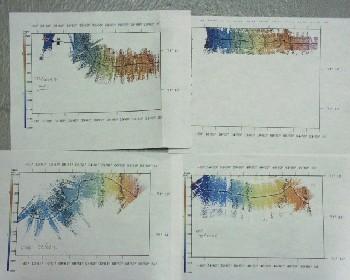
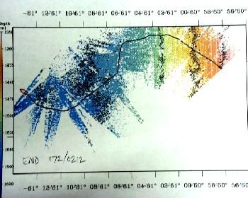
20 June, 2000The All-nighter: A Slow Decent into Mud I don't know if it was the excitement from seeing a mother polar bear and her two cubs at 8:30 last night, but I was able to stay alert until 02:00 A.M. I took the first watch of the all night bathymetric watch, from 10:00 P.M. until 2:00 A.M. You might be asking, "What is a bathymetric watch?" Drs. Larry Lawver and Lisa Clough, along with Jay and myself took turns watching the Seabeam and Knudsen data which gave a detailed mapping of the ocean floor. The sonar equipment mapped the topography of the ocean floor were we sailing above. The Seabeam system profiles the topography not only below the ship, but out away from the ship at a 60 degree angle, helping to profile a larger area than the normal sonar imaging. The Knudson sonar gave us two readings to interpret, a bottom profile and a subbottom profile. The bottom profile gives an image of the first layer of sediment on the ocean floor that the sonar detects. The subbottom profile indicates whether or not there is a layer of sediment above a bedrock base. Some of the sonar signal penetrates the surface of the sediment and continues down to a lower level, until it is also reflected back to the surface. If there is another layer, its echo pattern forms parallel dark bands on the image. The top band represents the top layer of sediment and the bottom band represents the top of the rock or more compacted sediment layer below. We were sailing to look for a desirable location to complete a rock dredge. The sort of terrain we were looking for was an area of the ocean floor with a steep drop-off, much like an underwater cliff. We were also looking for an area that did not have a layer of sediment; we wanted a rock outcropping that we could get a dredge bucket hung up on. The plan was to get the dredge bucket hung up to the point that the tension in the wire was near its maximum. Either the weak link in the chains that hold the bucket, or the rock outcropping would give way. Of course, we are wanting the rock to give way so that we will have some rock specimens to examine. Just after 7 P.M. we were sailing at 59 degrees 30 minutes North Latitude, 71 degrees 06 minutes West Longitude. By early Tuesday morning we had sailed to 61 degrees 13 minutes North Latitude, 71 degrees 16 minutes West Longitude with no luck in finding a suitable dredging location. We were beginning to realize that we were not going to find that ideal location. All we could find in the nine hours spent watching the sonar equipment was a steadily decreasing slope. We initially started with a depth of 580 meters and ended up at a depth of 1770 meters. This was about the time that I went to bed. But before I went to bed, plans were being made to stop the ship to determine the rate at which the ice we were in was drifting. To determine the drift from winds and/or current was important for the over-the-side coring operation that would begin around nine to ten in the morning. After determining the drift, the ship was then going to sail until the bottom topography leveled out and showed a deep layer of sediment. The deep layer of sediment will be necessary for getting a 30-meter core during the coring operations today. As I try to instill in my students back home, "Science isn't always pretty." Lab work in real life applications doesn't take fifty minutes, like typical classroom experimentation. Many scientists spend weeks, even decades studying the area of science they are most interested in. And even though you might spend an enormous amount of time and energy completing a specific task, it certainly does not guarantee that you are going to get the results you expected and hoped for. As the old saying goes, "If at first you don't succeed, try, try again." Yes kids, that means we are going to have to do it all again! "Oh, man."
Contact the TEA in the field at . If you cannot connect through your browser, copy the TEA's e-mail address in the "To:" line of your favorite e-mail package. |