|
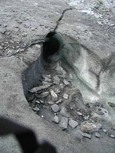
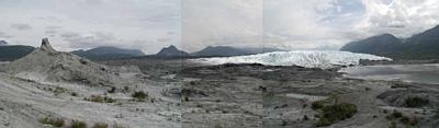
12 July, 2000July 12, 2000 Matanuska Glacier, Alaska This morning we once again retrieved samples from our two vent stations. After graphing the conductivities we feel as though we may have some good leads to investigate now. It still seems too soon to believe we have made a moulin/vent connection but today’s results provided us with enough information that we are modifying our procedure. Tonight we will increase the salt input and collect samples every thirty minutes instead of fifteen. We think we might be seeing something coming out at Little River Vent. We will be able to monitor a twelve hour period now in hopes that we might see a complete rise and fall in the conductivity. One concern for tonight is that a good rain fell at the same time we dumped the salt. We’ve already found that the rainwater has twice the conductivity of the vent discharges. Our hope is that it will affect both vents equally. I wanted to take a little time to talk about the Matanuska Glacier. It is located just off the Glenn Highway at Mile 102 about 80 miles northeast of Anchorage. It drains about 250 square miles of the central Chugach Mountains between Mount Marcus Baker and Mount Witherspoon. This glacier is considered to be a stable ice flow that is about four miles wide at its terminus and roughly twenty-seven miles long. It averages two miles in width. It is a valley glacier as it exists on a valley floor. Most other glaciers in Alaska hang off mountain slopes and are alpine glaciers. Work by the U.S. Geological survey in the mid-1950s showed that it was moving very little. They also found that moraines less than 200 years old were just a quarter mile in front of the terminus. A moraine is rock debris piled up along the lateral (side) or terminal (end) parts of a glacier or laid down beneath it, as well as to the accumulations of rock debris on its surface. The debris can consist of large boulders, gravel, sand and silt. Advances about four to eight thousand years ago left moraines one to five miles beyond today’s terminus. About 18,000 years ago it covered the town of Palmer more than fifty miles to the west. During the summer of 1979, part of the glacier advanced over 100 feet in two months. The terminus of the glacier is generally stable today. As I visit the different places around the glacier from day to day what strikes me is how much it changes. A visitor who stops at the parking area to snap a picture is missing an awesome experience if they don’t go out onto the glacier. There is so much to investigate on the ice. And the day visitor who ventures out onto the ice still misses so much. I am fortunate in that I see the glacier as a dynamic, ever changing spectacle. I cannot see the advance or retreat of the ice. However, I do see all sorts of features appear and disappear. I’ve quickly learned to take pictures at every chance. The opportunity may be gone tomorrow. It seems that every time I hike to the moulin there is something different along the way than the day before. The levels on two sides of a crack in the ice change. A large moulin appears seemingly overnight. Small trickles carve canyons much faster than you can imagine. Sometimes it seems that you could explain every landform on earth by observing processes that shape the glacier. I grow more and more fascinated with it every day! Marvin Giesting
Contact the TEA in the field at . If you cannot connect through your browser, copy the TEA's e-mail address in the "To:" line of your favorite e-mail package. |