|
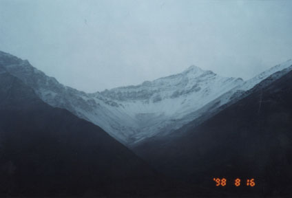
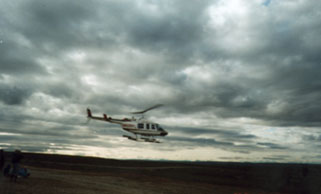
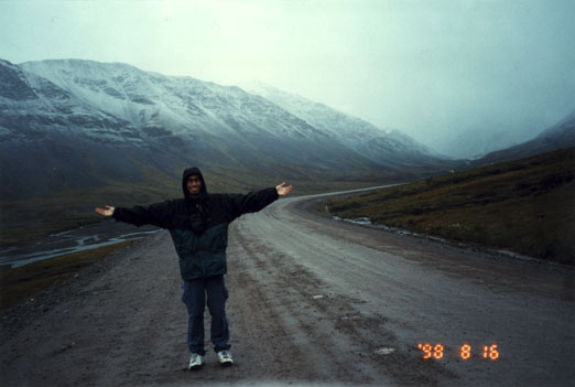
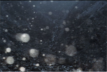
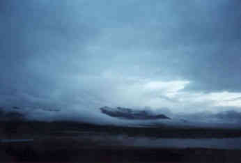
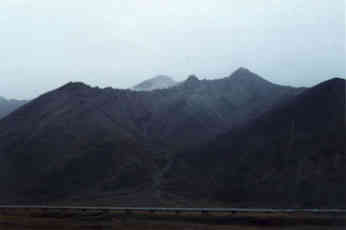
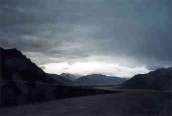
15 August, 1998August 15, 1998 Sag 3 & 4****Atigun Pass****Frost Mounds Today started off very early (7:15 AM) to head down to the Sag River sites. We had to leave so early because a helicopter could ferry us over the tussocks and save us a very long walk. This was my first helicopter ride and I think I would love to have more, although I know it is very expensive to get helicopter support up here. After finishing up probing and downloading the data logging equipment at Sag 4, Anna and I hiked the 1.6 miles out to the road and then went up to Sag 3, about 5 miles away. There we had a mile hike in to the site. Hiking in, we had to ford a stream that had large dwarf willow groves alongside. This is prime bear country! We were yelling and singing and talking trash to the woods in order to startle any bears that may have been in there. I'll tell you what, if anyone could have heard us, they would have thought we had tundra fever or something. Looking back it is pretty hilarious. While up on the Sag 3 site I found some single yellow poppies sitting in the middle of tussocks and mossy areas. There were some definite photo opportunities up there. Upon returning to camp (about 7 PM), we ate dinner and then Anna, Javier, and I took a drive down to Atigun Pass. It is about 50 miles to the south along the Dalton Highway and takes you through the Brooks Range. We finally got Javier his first snow. He was grinning from ear to ear and gazing all around. I can't remember my first snow but I am positive Javier will. The snow itself did look really pretty, especially with the darkness of rock that appeared in veins almost everywhere you looked. The mountains themselves are different from any I have ever seen. There are no trees! Only grasses and dwarf shrubs up to a certain level and then nothing but rock and dirt. The snow brings out the stratification of the levels of rock and it appears that you can see back millions of years simply by looking at a rock face. The valley that the pass is in is U-shaped, which indicates that it was formed by glacial activity a long time ago. There is running water seemingly everywhere, COLD water, and we got some pictures and samples (TOY). The way back to camp was also educational as we got to see, up close and personal, some frost mounds. Remember these mounds are formed by massive upheavals of ice which push the earth up into mounds. The ones we saw the other day at Slope Mountain were collapsed, but the ones that we saw today were in full form. We could even see the ice under the dirt. It was neat to see the stark beauty of the white ice in contrast to the brown of the dirt around it. These mounds were probably a little more than a meter high, but they covered an area of about 400 square meters. This is truly something that is only found in regions such as these. Today was great and I hope to see more things tomorrow when we do the Toolik Lake site. Sundays around here are a little more laid back so we probably won't get started until 11 or so. JAVIER"S PIECE I also have never been in a helicopter, so when Anna told me to ride in the front, I was a little reluctant. It was very exciting and I got quite a few good pictures of the tundra form the helicopter above. The actual site (Sag 4) was not as large a grid as the one kilometer Imnavait Creek type sites, so it was also a relief because I didn't have to do as much tussock walking - a relief for my feet. Actually, I get tired a little quicker than other people because Anna, the genius, told me to buy these boots in New York that go up to my thighs. This would make sense if the water level rose above my knees, but it never has, so I've been lugging around lead tied to my feet, while everyone else is just bouncing everywhere, filled with energy. (okay, maybe not.) After Don and Anna left to go to Sag 3, I stayed with Claire and Laura and Sam to help them take their soil moisture samples. It was interesting to see how they would collect these samples of dirt, which they later dried of all (or most) of the water inside. We returned to the road via the assistance of the helicopter and then set off for Toolik: Sam, Laura, Ron, and I. After dinner, we went to the Brooks Range and Atigun Pass. The road really takes a few turns on the way up and is quite steep on the way down. When I saw some white things hitting the windshield, I asked if it was snow, but it was only sleet (the difference is still a little fuzzy for me). When we turned around to go back up the pass, it really started to snow. That's when Anna and I saw this really picturesque waterfall inside of this rocky cut in the mountain. Don decided to stay in the car, even though the waterfall was really quite spectacular. Anna stood by the road to get pictures, but I deemed the structural integrity of the rocks stable enough so that I could get a closer picture. That's when it really started to snow and get slippery. I got about 10 meters away from it when Anna started yelling at me and reprimanding me for getting some great shots: she was just jealous. After we got back into the pickup and woke Don up, we decided to stop a little down the road to the head waters of a river. We snapped a couple of shots and Don obtained his glacier-water sample in a film container. While we were going back down the pass, we saw an ice mound. We all took pictures. It was like a cube of frozen ice, cut away at the bottom by running water, sitting in the bottom of this field with vegetation growing on it. There was another sample and on my way to see it, I almost fell flat on my face and into the water. I had stepped on a mound that was either old or getting there and it had collapsed under my weight. This was a very frightening experience, for about a second. Then I went on to admiring the snow and its grandeur. Today was a very eventful day and I used up about 20 pictures just in the Brooks Range. Hopefully, I'll be able to come back some day and really get the scope of its beauty with enough time. I can now see why people would want to camp in places like this; even though it is rough, the experience is something else.
Contact the TEA in the field at . If you cannot connect through your browser, copy the TEA's e-mail address in the "To:" line of your favorite e-mail package. |