|
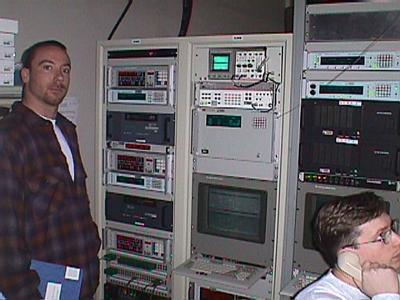
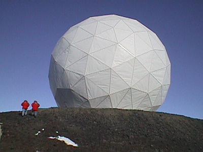
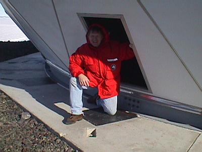
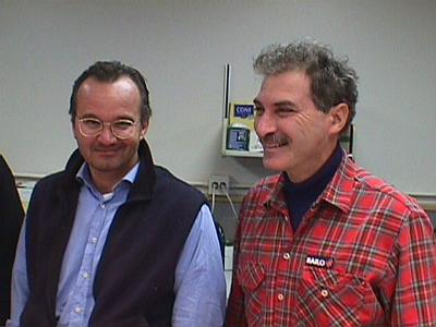
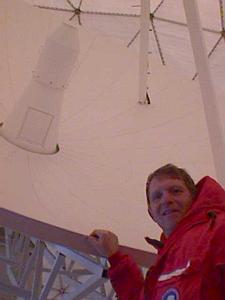
10 November, 1999The weather turned again in McMurdo. Low visibility and high winds. I spent much of the day in the lab processing samples. They keep coming in from the drill site. The most recent rocks drilled have been primarily clean coarse sandstones. The loose nature of the sandstones has caused some problems with the drilling. Also, the hard quartz grains are hard on the drill bits. These sandstones do not contain a lot of fossils. Active environments, like the ones that deposited these rocks, are not conducive to fossil formation. This dearth of fossils has made it difficult for the paleontologists to determine the age of the rocks. They know they were in rocks of the Oligocene Epoch (about 30 million years old). They are hoping to find rocks of the Eocene epoch (about 34 million year old) so they can explore the conditions in Antarctica at that time. They are unsure exactly the age of the rocks they are in. They have recently brought up a piece of fossil wood, but this has not given them any additional age information yet. They continue to drill. I paid a visit to "Ground Station Antarctica" the other day. This is a NASA facility that tracks polar orbiting satellites and downloads data from them. Antarcticas' location near the South Pole makes it an ideal location for tracking polar orbiting satellites. There is a similar facility at Poker Flat Research Range near Fairbanks, Alaska. Polar orbiters are in an orbit that passes over each pole. As the earth rotates under the satellite with each orbit a different swath of the Earth can be viewed by the satellite. This makes polar orbiting satellites ideal for mapping and other Earth monitoring missions. The Antarctic Ground Station also supplies support for NASA launch missions by tracking the rocket during and after launch. The facility is composed of a control room located in Crary Science and Engineering Center at McMurdo and a 10 meter dish antenna. The antenna is housed in a large, white fabric dome perched up on a ridge above McMurdo. The dome is a very prominent landmark from town. When I stopped by the control room, which is located across the hall from the lab I work in, Chuck Seman and Jamie Gallo were in the process of locking on to a TRACE satellite in preparation to downloading the data. The dish antenna is aimed by remote control at the satellite and at a pre-determined time, the data from the "bird" is downloaded to the ground station. The reason this is necessary is that the memory storage capability of the satellite is limited and the data must be continually removed. The data is transmitted to Goddard Space Flight Center in Greenbelt, Maryland for processing. The TRACE satellite is used to study the photosphere of the sun. The photosphere is where the magnetic fields of the sun interact with plasma to produce flares, prominences and sunspots. If you want to find out more about TRACE, check out this web site: http://vestige.lmsal.com/TRACE/. You will find some spectacular images of the sun. I also got a chance to see the 10-meter dish. The site also gives you a great view of Mactown and Mt. Erebus. Today's featured CRP Team Members are two members of the Italian contingent of the Cape Roberts Project. They are Massimo Sarti, a sedimentologist from the University of Ancona, and Marco Taviani, a paleontologist from the National Research Council in Bologna. Massimo works on describing the sediment structures and deposition environment of the core samples along with the other sedimentologists. Marco examines and identifies the macro-fossils found such as mussels, snails and clams.
Contact the TEA in the field at . If you cannot connect through your browser, copy the TEA's e-mail address in the "To:" line of your favorite e-mail package. |