|
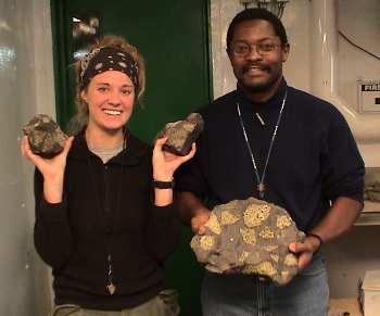
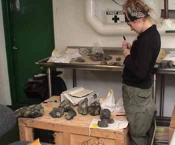
28 January, 2004For Sam Mukasa and Jill Van Tongeren from the University of Michigan it was a good day to catch up on some back work. Earlier in the cruise Sam and Jill with the help of many of the scientists, marine staff and crew had collected rock samples at Franklin Island. Over the past couple of days Sam had been looking over the collection formalizing a method to catalog each sample so that when he returned to Michigan he would have an inventory of the location and geologic feature where each sample was taken. Sam had washed all of the rock samples that he had collected and Jill was about to begin washing all of those that she had taken. As we talked, he and Jill labeled each sample with paint pen and permanent marker with an alphanumeric label. Each sample was then placed in a canvas bag, with the identification written directly on the bag and on a tag attached to the bag. Sam recounted a story about some rock samples that had been collected by many geologists in many areas over many years that had been mixed together as the result of an earthquake in California. The samples had been placed in bags, but the rocks had not been labeled directly. During the course of the quake, the shelves that the rocks had been stored on broke and the samples all came crashing to the floor. This would not have been a problem, but the samples were collected over so many years that most of the collection bags were old and brittle and broke when the samples hit the floor. When the geologists began attempted to reorganize and identify the samples, they could not. They were left with a pile of interesting rocks. In addition to the collection bags and direct labels, Sam and Jill had also recorded information about each sample in a field journal, and many of the more unusual samples were photographed as well. When they get the samples back to Michigan, they will make thin sections of the rocks to look at their structure under the microscope. Their emphasis will be on looking at the chemical composition of the rocks looking in parcticular at trace radioisotopes that will help them to date the age of the rocks. From this isotope data they can age the flows from which they samples were originally taken, producing a timeline for the volcanic events that formed Franklin Island. They will be very interested in the magma nodules. These nodules contain crystals that are formed by minerals that cool more rapidly than the surrounding rock. The most common mineral that they will find is Olivine. If the nodules that are exposed to the elements the Olivine will be weathered. Weathering changes the chemistry of the rock and reducing the reliability of the isotope dating from those nodules. They will try to locate "fresh" nodules as they make their cross sections to provide them with unaltered crystals for their analysis. We continue to do multibeam surveys of the area around Franklin Island looking for potential volcanic formations. Some of the initial data looks promising. Efforts are being made to improve the data being collection and analysis for the seismic streamer.

Contact the TEA in the field at . If you cannot connect through your browser, copy the TEA's e-mail address in the "To:" line of your favorite e-mail package. |