|
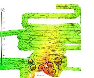
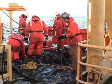
29 January, 2004The process of science is about inquiry, finding out new things about the world around you. The past week or so we have been looking at the seafloor with the sonar and seismic equipment and asking questions about the things that we think we see from the preliminary data. Today the scientists started to try and pose some answers to the questions that they have been asking. After all the multibeam surveys, and the beam editing, a preliminary map of the seafloor in the area between B15A and B15K has been completed. Of parcticular interest to the scientists is an area south of Franklin Island that features a collection of seamounts. This area will become the focus of survey work for the next day or so. Seamounts are volcanic formations on the ocean floor that are formed as a result of lava flows building volcanoes below the ocean surface. The seamounts were approximately 250 meters in elevation, but the tallest seamount was still more than 100 meters (310 feet) below the surface. The seamounts are arranged in a cluster, all of similar elevation, but of different steepness. We plan to collect rock samples from two of the seamounts using a dredge as we had earlier in the cruise. One of the dredges will be conducted this evening and the second tomorrow morning. Now that the scientists have focused their investigation, they will look to add supportive data to their initial findings. More attention will be paid to collecting magnetic data with the magnetometer and bathymetric data using the "Simrad" system. The magnetometer can supply some information about when and how the rocks in the seamounts were formed. All rocks contain elements that can be affected by the Earth's magnetic field. The most common is Iron. When Iron is present in molten lava or hot rock that has begun to solidify, the Iron atoms are very free to move. Electrons in the atoms orient themselves in the direction of the magnetic field, which in the case of these seamounts is the magnetic field of the Earth. Over the Earth's history, the magnetic field has changed directions, strength, and on occasion the north and south magnetic poles have switched. When a rock cools, it keeps a record of the direction of the Earth's magnetic field at that time. Changes in the magnitude or direction of the magnetic field strength of the rocks that make up the seamounts give the scientists an indication of the volume of flows that produced the volcanic formation over time and, when compared to known times when the Earth's field switched from North to South poles, some indication of the geologic age of the flows. Many hands made fast work as the first dredge was brought on deck. When they came up, the samples were mixed with thick muddy sediment that had to be washed off of each rock individually. Following the same procedure as the first dredge, rocks were selected and rinsed with seawater and separated into groups of general and special interest. Mud and sea creatures caught on the ride were squeegeed over the side. The collection of rocks from this dredge was substantially smaller than the first. This is not unusual, but was a bit disappointing. Over the next few days Sam Mukasa will catalog the rocks from the first two dredges to be taken to Michigan for further analysis. Sometimes the activities of the day cross over watch times making for a long day, but the excitement of being the first one to see what hits the deck out of the dredge is more important than sleep. Special thanks to Dr. Terry Wilson for her editing and review this entry, and her corrections and additions.

Contact the TEA in the field at . If you cannot connect through your browser, copy the TEA's e-mail address in the "To:" line of your favorite e-mail package. |