|
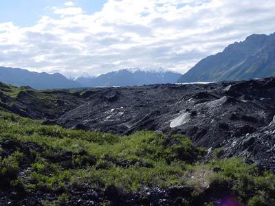
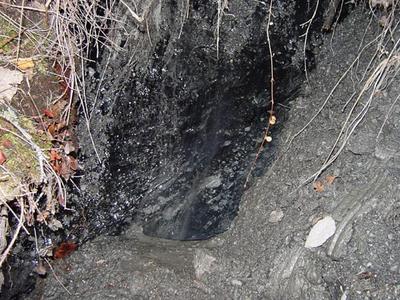
30 July, 2002A hike in the woods........ Today I helped out Tim Alessi, the REU student from the University of Wisconsin at Oshkosh. His project area is in a moraine area to the north of the terminus of the glacier. The area is covered, for the most part, by forest. Buried ice still exists beneath the sediments that the vegetation is growing on. With his project, he is attempting find a correlation between the age of the forest in this moraine area and the depth of the sediment over buried ice. This information will then be compared to other models of glacial karst topography. He has set up a profile line that runs in a general northward direction for 1400m. It begins near a boundary between non vegetated moraine and moraine that is vegetated. The profile ends at the Matanuska River where bedrock is exposed directly at the surface. I helped Tim collect samples of soil from the area. At 100m intervals across this profile, we removed a soil sample that will be studied for information such as depth of the soil, structure and nutrient content. The soil at all of these sites was very shallow yet in many of the areas there was relatively mature forest. At each interval we also collected a tree bore sample. This is accomplished by using a device that drills a small hole into the tree, but leaves behind a core in the middle of the drill hole that can be removed. By counting the rings of the sample an age for the tree can be determined. This information is important because it gives an idea of how long ago conditions were suitable for tree growth, and an estimate of how long the ice that is present has been there. At some locations, trees were found that were well over 100 years old. Thatąs a long time for ice to be melting, so imagine how massive the buried ice must be! As the ice melts out from beneath the sediment covering it, the surface landscape changes. The vegetation that grows on this ever changing landscape shows these changes in many ways. Today, I saw many examples of this. There were trees that were split right down the middle, as land on one side of the tree settled relative to the other side. There were also areas covered by what is referred to as łdrunken forests˛. When ice melts out from beneath the sediment and soil that supports a forest, the trees lean in many different directions giving the forest an overall łtipsy˛ appearance. Life Is Good DT
Contact the TEA in the field at . If you cannot connect through your browser, copy the TEA's e-mail address in the "To:" line of your favorite e-mail package. |