|
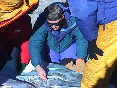
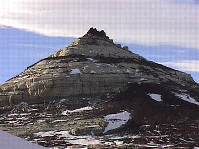
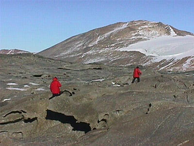
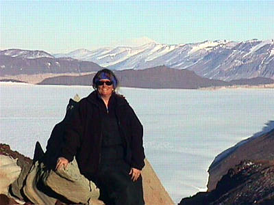
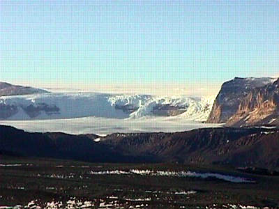
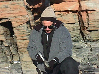
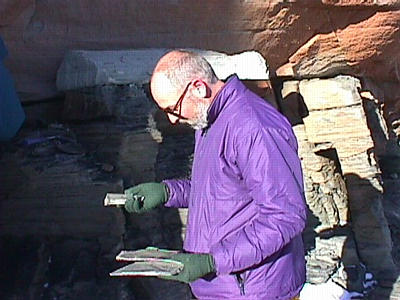
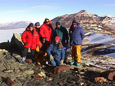
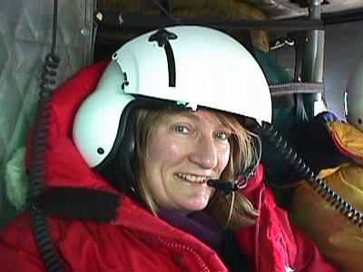
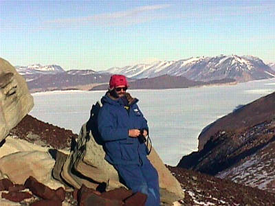
3 December, 1998Thursday, December 3rd, 1998 Hi! Just when I think there can't be another thing on this trip to top what I've already done…along comes a day (night) like today! The Dry Valleys of Antarctica…probably one of THE most fabulous places I've ever visited on Earth. Actually, it didn't look much like Earth at times…I felt like I was on the moon or Mars. Amid all of the snow and ice in Antarctica, it seems strange to find a desert landscape. The never-ending winds of this region are about the only thing that has changed the look of this landscape for millions of years. The Trans Antarctic Mountain range stretches for more than 1,370 miles and is one of the world's great mountain chains. Many of its peaks are higher than 13,000 feet above sea level, although they are all but buried in ice. This mountain range acts as a barrier for the world's largest body of fresh water- the east Antarctic ice sheet. Glaciers, great rivers of ice, have carved deep valleys through this area, as they force their way to the Ross Sea. Since the mountains have been uplifted in the past 30 million years, some of the mountains are now high enough to keep the ice sheet from flowing through all of the former outlets. Robert Scott discovered the Dry Valley region by accident, on his Antarctic expedition in 1901-1904. He descended into one of the valleys while sledging (hauling his supplies) down a glacier toward McMurdo Sound. He couldn't really explore this area, since his equipment was made for sledging over ice. Scott and his men had to re-trace their steps and climb up the glacier again. In 1909, Shackelton sent two men to explore the eastern end of what is now called Taylor Valley. In 1911, Robert Scott sent Griffith Taylor, his geomorphologist from the Terra Nova expedition, to sledge up one glacier and down another, and then hike through the valleys. Taylor Valley was named after Griffith Taylor, and I was surprised to learn that Lake Bonney was named after one of Robert Scott's dogs. I was anticipating this field trip ALL day. It had been postponed for the past two nights, due to poor visibility in the mountains and high winds. Today was blue sky, sunny, and BEAUTIFUL! I worked all day on little odds and ends. I cleaned out the drill shack, which was covered in mud. I had a meeting for the CRP open house coming up this Sunday. I worked on answering e-mail and writing. I was really happy when I could catch an early dinner and head to my dorm room to change into that darn ECW gear. It's not the most comfortable stuff, and certainly not flattering, but it sure keeps me warm! And, as I've mentioned before, it's required if we fly on a HELO or leave McMurdo on a field trip. I reported in at the helicopter hangar at 6:00 PM, along with Gary Wilson, Tom Janecek, Rosie Askin, Jaap Van Der Meer, Mike Tabecki, Reed Scherer and Graeme Wilson. The eight of us were sandwiched into the back of the HELO, cameras ready, helmets on and plugged in for communication between pilot and eachother, and seat belts fastened. We were off the ground by 6:40 PM. Tonight we flew out of McMurdo through the gap (pass) between McMurdo and Scott Base. After circling around Scott Base, we were pointed in the direction of the Trans Antarctic Mountains and the Dry Valleys. Since it was such a clear evening, I got a tremendous view out my side of the copter. I was facing McMurdo and Mt. Erebus (yes, more Mt. Erebus photos!). The best part for me was thinking about all I've done since arriving in Antarctica. On many of my field trips I've traveled the same path out of McMurdo…and I could re-trace my various trips from the air. I saw Big Razorback, Tent and Inaccessible Islands (all from my day with the scientists studying seals), the Erebus Glacier tongue (where the ice caves are located), Cape Evans (Robert Scott's hut), the Barnes Glacier, and Cape Royds (Shackelton's hut and the PENGUINS!). It was nice to reminisce and have one more look at this incredible landscape from the air! I could see beyond Cape Royds, out to the open water. I would love to be in McMurdo when the ice breaker arrives later in the summer season. Now THAT would be something to see from the air. Off in the distance there was the far coast of Ross Island, and another smaller island, Beaufort Island, was also visible. I love the views you can get from the air…shows you just how vast this Antarctic landscape really is. There seems to be no end to it…quite unbelievable! By 7:20 PM we were landing in the first of several locations in the Dry Valleys. We had already flown into the mountains and over glaciers and valleys below. This was a special moment, because it was the first time I was going to set foot on the main part of the continent of Antarctica. I've been on Ross Island (Antarctica) for the whole time I've been in and around McMurdo. This was going to be different. The pilot, John, landed the HELO on Nussbaum Riegel-a ridge above Taylor Valley, the Taylor Glacier, Lake Bonney (at the end of the Taylor Glacier) and the Suess Glacier off on a side mountain. Gary Wilson, who served as our tour guide for the night, immediately started giving us facts about this region. I had to pay attention carefully, because I don't have the geology background that the rest of my group does! Still, I learned a lot tonight about the geologic history of the Dry Valleys. At this first stop, we found many ventifacts. Ventifacts are rocks that are shaped and polished by windlbown sand and snow. These rocks are smooth on some surfaces and have been "chiseled" by the wind into sharper corners on others. The ventifacts are carved into unusual and sometimes complicated shapes. We also saw examples of dykes-strips of intrusive igneous rock that has been injected into earlier intrusive igneous rock and sediment. Intrusive rocks are those that cool under the Earth's surface. Pumice is an example of an igneous rock that cools above the Earth's surface (extrusive), while granite is a good example of a rock that cools below the Earth's surface. Lots of granite could be found on Nussbaum Riegel. The way that some of the dykes stood up out of the other rock, reminded me of a "comb" on a rooster or a little ridge of rock jutting out of the ground. These rocks were also darker in color, making them easy to spot. We probably spent about an hour at this stop, although it was hard to tell, since the time went by so fast. Before we knew it we were strapping in for our next short HELO ride… toward Finger Mountain, over Pandora's Spire and Taylor Glacier, toward Aztec Mountain. We landed on the shoulder of Aztec Mountain, which is about 6,500 feet above sea level. Our group climbed UP Aztec Mountain to about 7,000 feet above sea level, to a sandstone level of the mountain. Gary wanted to look at the coal measures (made of sandstone and siltstone) to try to find fossilized leaves of an ancient deciduous conifer called Glossopteris. He used a geology hammer to chip away and separate the layers of rock, then pried the layers apart with his hands or the hammer. I used the time to do the same with my hands, and also took quite a few photographs of the area and the people in my group. We weren't at the top of Aztec Mountain, but still had incredible views of Beacon Valley, hanging glaciers, and other valleys and mountains surrounding us. The hike up and down Aztec was strenuous, if only because of the change in altitude. Back in the HELO in 1 hour and 45 minutes….and off to the next destination. We crossed over a formation below called the Labrinth…carved channels. Scientists don't know how they got there, but Gary did tell us that the channels are much larger than we think they are from the air. You can fly helicopters in them, and I can see where they got the name Labrinth…it's like a maze down there! John took us over the Asgard Range and to the Airdevronsix Icefalls (named after the Navy division that used to provide the plane and helicopter support). The Icefalls spill over the edge of the Wright Upper Glacier and are absolutely incredible!!!!! I've been walking by a painting of this area for weeks now (it's in Crary Lab) and suddenly the painting takes on a whole new meaning. John flew us close to the Icefalls, heading in both directions so that each side of the HELO could get a good look. WOW! I don't think the digital photo taken from a distance will do it justice, but I want you to get a look at this scene!!! Within minutes John was looking for a place to land on the Dais. This reminds me of a plateau, but wasn't as flat as it looked from the air. It was kind of tilted, but level enough to land the helicopter. Part of our group walked to one edge of the plateau and took a look at a small lake below that never freezes (even in the cold Antarctic winter) because it has such a high salt content. We walked to the opposite edge of the Dais and gazed down at Lake Vanda in the Wright Valley below. On the steep sides of the valley there are hanging glaciers…meaning, they hang down the side of the main valley. I know they have to be HUGE and I wonder why they don't break off and tumble down into the valley. The glaciers we could see include: Bartley, Meserve, Hart, Goodspeed, and the Denton Glacier. When John took off from the Dais, he flew directly INTO the Wright Valley and he followed the frozen, winding Onyx River. This small stream was showing signs of melting for the season, but wasn't yet flowing freely. Off to the left…one of the remote field camps. Our landing in Wright Valley was another perfect one….smooth as can be. Gary had John put the copter down near two small "mesas" on the valley floor. Prospect Mesa, the larger of the two, has been a topic of study for many years. Some of its sediments were deposited from ancient fjords in Antarctica. The top sediments were a glacial deposit, then the fjord deposit, and the bottom sediments were a glacial deposit laid down in water. On Prospect Mesa Gary showed us shells-called pectens-which is the name of a mollusk. These shells are a few million years old. The remainder of John's route toward McMurdo Sound followed the Wright Valley…to the Wright Lower Glacier and eventually the Wilson Piedmont Glacier. We headed to Marble Point to refuel, which only took about 10-15 minutes. We were able to get out of the HELO and stretch our legs…eight people scrunched inside the HELO…tight quarters. Plus, by this time of the night, after the on/off business with the helmet for hours, my hair was sticking out and blowing all over the place in the wind. No one in our group even had the same helmet we started with because we had been rotating around in the HELO to give everyone a chance at being by the window. By this time it was around 1:00 in the morning, and people were beginning to fade! I enjoyed the 40 minute ride back across McMurdo Sound. John took us directly over the ice edge and open water and we THINK we saw Emperor penguins. They certainly looked a lot larger than Adelies, and the flight assistant made the comment that they looked like bowling pins down on the ice. I'm counting it as Emperors anyway. Why not! I liked seeing the open water up close. For weeks now, I haven't seen much variety in landscape…other than some mountains looking higher than others and a few islands, huge glaciers, and icebergs. Not that it's been bad at all. But…the blue water stretched out for miles…everywhere to the left of the helicopter. I am starting to imagine what it will be like to get back to New Zealand and see lots of color again. The Kiwi passengers were dropped off at Scott Base first…five minutes later we were landing in McMurdo. It was 2:00 AM…what a long night. Thanks to Gary for being a GREAT tour guide and to John for flying us safely around the Dry Valleys tonight. At last, all of us trudged up the hill from the HELO pad to our dorms…I was exhausted! What a FABULOUS night! I hope you enjoy the photographs of one of the most unique places on Earth…the Dry Valleys of Antarctica. Talk to you tomorrow! Betty :)
Contact the TEA in the field at . If you cannot connect through your browser, copy the TEA's e-mail address in the "To:" line of your favorite e-mail package. |