|
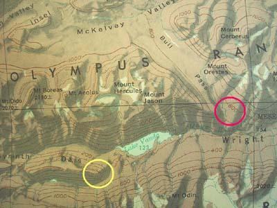
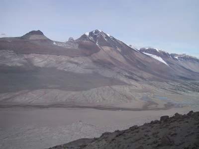
10 January, 2003Dais When the Dry Valleys formed, magma came up in columns and, at the top, capped and spread out to form sills. The Dais is a major regional feeder of this magma. It gets its name from a flat table or podium. The Dais is located about 8 miles from the Bull Pass camp and will be a major area we will investigate. The central science theme then is to try to describe the basic magmatic system that is responsible for this area of Antarctica. Because the Dry Valleys are not overrun by vegetation or eroded by rain, the "plumbing" which formed the region is exposed and provides an outstanding model for magmatic systems all over the world. While these systems could be explored elsewhere, nowhere is this type of exposure so prevalent and pristine as it is here. The major sills in the Dry Valleys are known as the Basement Sill, the Peneplain Sill, the Asgaard Sill, and the Flemming Sill. The Basement and Peneplain sills are the ones we've seen the most. From north to south, the three main Dry Valleys are Victoria (and a branch known as McKelvey Valley), Wright, and Taylor. Bull Pass is located between McKelvey and Wright Valley. The air is so dry in the Dry Valleys, which cover about 1200 square miles, that they have virtually no snow or ice. Such ice-free areas in Antarctica are called oases. The conditions required for an oasis are a retreating or thinning ice sheet, and a large area of exposed rock from which snow becomes ablated due to solar radiation absorbed by the rock. Oftentimes we have observed the heat emanating from the rocks similar to what you might observe from the surface of a road in the summer. The Dry Valleys were formed when the terrain uplifted at a faster rate than the glaciers could cut their way down through them. Eventually, the glaciers were stopped by high necks at the head of each valley. Robert Scott accidentally discovered the first of the Dry Valleys in December 1903 and named it for geologist Griffith Taylor. Scott and two others had sledged up the Ferrar Glacier to the East Antarctic Ice Sheet. On their return, they became lost in thick cloud and descended the wrong valley. Because they were equipped for sledging, not hiking, they were forced to turn back after a brief exploration. In The Voyage of the Discovery, Scott wrote: "I cannot but think that this valley is a very wonderful place. We have seen today all the indications of colossal ice action and considerable water action, and yet neither of these agents is now at work. It is worthy of record, too, that we have seen no living thing, not even a moss or a lichen; all that we did find, far inland amongst the moraine heaps, was the skeleton of a Weddell seal, and how that came here is beyond guessing. It is certainly a valley of the dead; even the great glacier which once pushed through has withered away."
Contact the TEA in the field at . If you cannot connect through your browser, copy the TEA's e-mail address in the "To:" line of your favorite e-mail package. |