| |||||||||||
|
|
Journals 2005/2006Greer Harvell
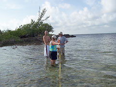
July 7, 2005 Today I was a member of the team designated to survey the shoreline for mollusks, crustations, plants, and birds. We began our task by measuring a section of shoreline that extended 50 meters into the water, 50 meters onto the land, and 50 meters on either side of the starting point. Looking from above, it would appear to be an x and y axis with the shoreline following the x axis. This hundred meter stretch was divided into sections 10 linear meters in length.
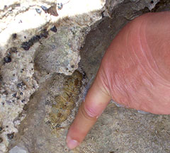
Once this was accomplished, we were given a square made of pvc pipe that measured approximately on square foot, or 900 cm. Once the square was placed randomly on the shore, and we were to count and log the number of each species contained in the area. Our next "mission" was to determine the change in elevation from the water's edge, 22 meters inland to the mangrove thicket using a zip level. The zip level is a digital means of measuring elevation and using it helped to determine that the elevation increased 0.754 meters. Our final job of the day was to measure, using a caliper, the length and girth of the furry chitons, a mollusk that resembles a flattened rollie pollie surrounded by fringe. We only measured the first 50 that were attached to rocks in places that were conducive to accurate measurements. Many of these creatures had attached themselves to crevices so deep into the rock that making accurate measurements, using a caliper, impossible. This data is to be compiled into a chart depicting the size frequency distribution of chitons prior to the development of the property.
|
||||||||||