| |||||||||||||||||||||||
|
|
Journals 2005/2006J. Rebecca Gould Calabro
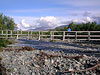
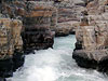
August 9, 2005 I was looking forward to the lectures by Anders Holmquist. My students and I would be focusing on Earth history and planetary science. I was hoping for some inspiration and content enhancement that I could transfer into the classroom. We stood on a wooden plank that overlooked a mound of cobblestones, pebbles, and rocks. It did not look very interesting and it looked rather chaotic. It certainly did not look like any place that I would have chosen to stop and view the surroundings. Anders used this opportunity to show us how everything was the result of some product. If you gulped a can of soda, then the product was that you are not thirsty. If you brought a CD from the current rapper, then the product was that the rapper's wealth increased. What, then, could possibly be the process that created this mound of rocks leading to the canyon? What was the process that created the Abisko Canyon?
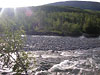
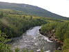
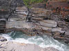
The product might have been a torrential downpour that carried down these rocks in the form of a rockslide. Perhaps people had to scurry out of the way! Or perhaps the streambed was a lot older. Maybe a huge glacier that slid over the stream and deposited huge rocks hundreds of times larger than I am. Over the years, these rocks were weathered down to the size of a pebble. Or maybe the rocks that I am standing on were placed here much more recently. Maybe an avalanche brought down a huge amount of snow that had once been up at the top of the ridge. As the snow melted in the summer time, these rocks were tumbled down by the massive snowfall. Does it matter which is correct? It is more interesting to speculate on what could have happened. Then we can look at how our world was created and changed in years past. When we were back in the classroom, we began to look into basic geological principals. We looked at how geologically define the Arctic climate. Typically this is done through an analysis of the weather. Climate patterns are determined in thirty-year cycles. In addition, the climate is the most important factor of any ecosystem. We did an activity that I will share with my middle school students. I will modify the activity so that the regions are more Boston-friendly. This activity involves defining what the Arctic climate is. I feel that it will help my students understand the region that they live in and how it differs from other parts of the world. There are several ways that people currently define Arctic conditions. Some people have determined that if you are further north than the Arctic Circle, you are in the Arctic north. I confess that before this Arctic Ecology course, I fell into this group of people. My excitement at simply being in a location that was above the Arctic Circle was simply because I felt that I was near the North Pole and was entering a climatic region I'd never before been. I do not think that Abisko is the Arctic north anymore; I think it looks like a miniature New Hampshire-that is well on it's way to becoming Arctic conditions but still very sub-Arctic. A second definition of the Arctic north is to look for an area where the tree line has completely disappeared. This definition, I feel, is too loose. After all, almost any hike I have done in New England guarantees that I leave the tree line but I do not believe I have hiked into Arctic conditions. Finally, we came to the third definition of Arctic conditions. This states that the Arctic conditions exists whenever in places that the temperature never exceeds 10 degrees Celsius (50 degrees Fahrenheit). By this last definition, there are not too many places that meet the criteria of an Arctic climate. Perhaps in another thirty years there will be more (or less). The rest of the afternoon we discussed our upcoming excursion to Narvik tomorrow. Narvik is a coastal town in Norway situated in the northern Norwegian Sea. The Gulf Stream current ensures that Norway receives a lot more rain than Sweden does. This is the same current that hugs our coastline in the summer and spring bringing with it warmer weather. It is also the same current that turns south away from the Boston shoreline allowing the Canadian Artic winds to seep into the New England regions. Despite Norway and New England sharing the same Gulf Stream current, Norway's shoreline is very different from New England. Norway has many fjords that were originally created through the glaciers of the last two ice ages. A fjord is a long, narrow sea inlet that is bordered by steep cliffs. New England's shoreline, although we have rocky cliffs as well up in Maine, tends to be a combination of sand and rocks that create the border between land and sea. Our geological excursion tomorrow would be to climb up to explore an actual glacier. A glacier is formed when climatic conditions are very cold and are suitable to lots of precipitation. Today the glaciers often are created on mountain slopes. The climate of the slopes is so cold that the snow cannot melt away in the summer. The next winter sees more precipitation that accumulates over the existing snowfall. This pattern continues until the snow volume is so thick that the glacier begins to move. This glacier, like most of the glaciers today, is beginning to melt and is retreating away. But thanks to the ARMADA Project's generosity, I would have the opportunity to get up close and personal with the Sleeping Queen glacier! |
||||||||||||||||||||||