
 | |||||||||||
|
|
Journals 2008/2009Heather Judkins
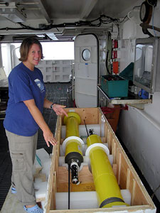
August 11, 2008 Today I had some time to learn about ARGO buoys from Ryan, the oceanographer onboard. An ARGO buoy is a small autonomous, torpedo shaped device that is deployed from a ship out at sea and they record the conductivity, temperature, and density of the water column. Once a buoy is deployed, it stays at the surface for 10 hours and then slowly sinks to 1000m collecting the data from the surrounding water. It runs on a 10-day cycle, which means that on the last days of the cycle, it sinks to 2000m and records information as it slowly rises back to the surface where it transmits all its data via satellites to an international database. Once the data is transmitted, it slowly starts its descent to 1000m to repeat this cycle. The buoys are able to record and transmit information for 5 years before the signal dies out.
The 3175 buoys that are currently floating around the world's oceans are part of an international project with 23 countries dropping buoys into the oceans. The goal is to have buoys circulating in the oceans every three degrees of latitude and longitude. Why? There are many reasons to have these instruments in action. They are able to give valuable information about the ocean circulation and climate patterns. It will provide a description of the changing state of the upper ocean and the patterns of ocean climate variability from months to decades, including heat and freshwater storage and transport. The data will be used for initializing ocean and coupled ocean-atmosphere forecast models, for data assimilation and for model testing. Additional information about the ARGO Project is at the website, www.argo.net. There are informational facts, a tracking map for the buoys, and more about how it works and who is involved.
I think the most ingenious aspect of the ARGO buoy is the buoyancy mechanism that is used to allow the device to sink and rise within the water column once it is activated. The whole operation depends on one cup of oil! The oil is slowly transferred into a chamber ,which will allow the device to sink or rise as needed. When the buoy is at the surface, transmitting information, there is a small air chamber that fills to give the buoy just a little more lift to transmit successfully. Then the air is released, the oil is pushed back into the system and down it goes again! Question 1: Where does the name ARGO come from? Question 2: What are some things that may interfere with either the floating capabilities of the buoys or the transmission to the satellites? (List 3) |
||||||||||

