| |||||||||||||
|
|
Journals 2005/2006Jeff Manker
August 21/22, 2005 We got to the boat this morning about 11:30am and shuttled gear, groceries and people to the boat via the zodiac. Today was thankfully calm. We planned on running another transect regardless of how long it took. We expected to be back by 1:00 am the next morning - instead, we didn't get back to our beds until 4:30 am! Anyone who thinks scientists are wimps hasn't met these people. They are all very dedicated and stay at the job until the work is done. Every evening when we get back and I drag myself to bed, they are still at it in the lab, sometimes for hours. Let me explain about the transects. The boat follows a predetermined line of coordinates that run out from the shallows near shore into the deeper water. Along the way we deploy the various instruments and take readings along the course. In the process we get a line of data that reflects properties in the water. The lines are set up to cross the bathymetric contours at approximate right angles, as certain trends in the water (temperature, salinity, etc.) tend to follow the contours.
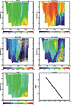
As we headed out, the first instruments to be deployed were the ADCP and the Acrobat. On the way into deeper water these two instruments give us a picture of fronts where the conditions in the water change. One of the terms I hear frequently here is "ground-truthing". This refers to getting data to substantiate theoretical models. After finishing the first pass over the transect, Steve Okkonen showed me the data we had collected using the Acrobat.
On the same transect I observed several species of birds in one particular area. From my field guide the Red-necked Phalaropes were described as being... "found along lines of floating weeds and debris. Picks minute prey from waters surface while swimming." The Kittlitz's Murrelet habits were described as "Feeds on small fish and plankton." When we matched the latitude and longitude of his data and my sightings there was a strong correlation between the location of the birds and the abrupt change in the water. After miles and miles of no birds, suddenly these birds are found right at the edge of this front. One of the purposes of coming to Barrow to collect samples and make observations was to find these kinds of connections. These birds were at that particular spot for a reason. To my unsophisticated eye the ocean surface looked all the same, and yet these creatures and the Bowhead whales, which are the subject of this study, recognize subtle clues that lead them to places that create concentrations of food or other desirable conditions. We had just ground-truthed the data and my sightings had helped do it! This was a great"Ah-hah!" moment for me. When we reached the end of our line we stopped, brought in the ADCP and Acrobat. With the data that they had collected the scientists began to look for where we should now take a closer look using the CTD Rosette, the VPR and plankton nets.
Once the sites were decided upon (usually one on either side of a recognizable front to identify the characteristics of either side), we set out and began deploying instruments and gathering data. We worked on through the night (though it never really got completely dark) finally reaching our anchorage after 4:00 am. Up again around 11:30 am the scientists spent the day downloading and analyzing data while I worked on my journal. Barry Scherr (another scientist on the project from Oregon State University and Aaron's advisor) had stayed ashore to work on water samples in the lab. He was already hard at work on the new samples we had brought him. Tonight we will head out again about 11:00 pm for our longest transect yet. |
||||||||||||