| |||||||||||||||||||
|
|
Journals 2005/2006Sarah Mitchell
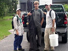
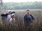
June 30, 2005 This morning I met with Guy DiDonato and Anne Blair, who I would be working with as part of the Tidal Creek monitoring crew. Our job is to go out into the field and collect the data which is then analyzed to determine what impact various levels of land use has on the quality of tidal creek waters. As the primary hydrologic link to land-based activities, tidal creeks are the first area to come in contact with the waters that runoff the land. The value of the tidal creeks and other wetlands is well known. They are nurseries, spawning areas, and feeding areas for a wide variety of animals. They also have recreational and commercial value. While many enjoy watching or catching animals that are dependent on such habitats, the lure to live near them has also led to an increase in development in coastal areas. With development, come roads, parking lots and roofs, all examples of impervious surfaces. As rainwater falls it is no longer soaked up by the soil, but rather runs off, carrying with it whatever it may pickup along the way. Land use in the state of South Carolina was divided into 4 categories, based on the percentage of impervious surface area. Tidal creek systems across the state representing each of these categories were chosen to be studied. The creeks were then subdivided into orders and reaches. Today our team worked in the first order of Bull Creek. Each site is visited twice to allow for all the colleting, and today was the second day at this particular site. On this trip the focus was to seine predetermined sections and to collect the sonde which was deployed yesterday. Bull Creek is classified as an upland, urban creek, and access to our various sample sites was best obtained from roads. Arial photography was used to determine the closest access points, which in this case was a housing development. We drove to the parking lot, applied sunscreen, put on our field boots, grabbed our gear, and headed into the marsh. A GPS helped to determine the exact sites we were looking for, however, in the marsh, a straight line, is not always the best.
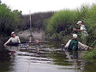
The higher elevations in the marsh are colonized by junkus or Black Needle Rush. As the name implies, the tips of this plant are like needles. Wearing long protective clothing was certainly good advice. We walked through the junkus until we came to a very well defined transition with the spartina. The ground was slightly less firm here, so we stayed along the border zone until we needed to head towards the creek. Despite the thickness of the vegetation, as we got into the spartina, the earth often seemed to give way beneath our feet. The closer we got to the bank of the creek, the mushier the ground got. At each of three predetermined sites, we needed to seine a 25 meter stretch. A seine net is a small hand held net worked by two people. Each person holds a pole which is attached to the end of the net. The bottom end of the net is weighted down and the top edge has floats. As you walk along, you tip the bottom end forward and critters larger than the mesh are scooped up and caught in the net. I have seined before, but never where walking was so difficult. Walking in this "pluff" mud the pole was sometimes helpful to get a foot loosened out of the mud. The critters collected were labeled and bagged to be taken back to the lab where they are studied by another team.
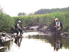
Before leaving we also had to collect the sonde that had been put out during yesterday's visit. Attached to a pole in the middle of the creek, this instrument had been monitoring various parameters of the water every 15 minutes for the last 24 hours. The sonde is detached from the pole, the pole removed from the mud, and then with everything either in a backpack or are arms, we made our way back to the truck. It felt odd walking through the parking lot of a development as muddy as we were, but nobody seemed to notice. After putting the specimens on ice and giving ourselves a basic cleaning, we loaded up and headed back to the lab area. All the gear needed to be hosed down, and the critters caught in the seine net needed to be cleaned and preserved. The catch was cleaned using small mesh screens to hose off some of the mud, then placed in labeled bottles with preservatives. |
||||||||||||||||||