| |||||||||||||
|
|
Journals 2005/2006Sarah Mitchell
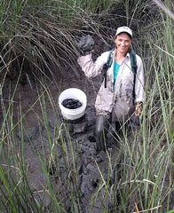
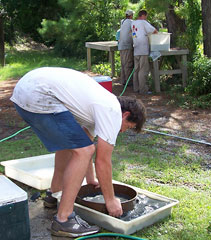
July 5, 2005 Today we were back in the field, and it was the first of two days at the Guerin Creek site. An unexpected advantage of this job is that to access the various sites, I got to see a fair amount of the surrounding area. Our drive today took us through a very developed area to an unbelievably remote one. Surrounded by upland woodlands, with no sign of civilization in site other than the road, we pulled off near a small bridge that crossed the creek. As mentioned before, the sonde is deployed and left in place for 24 hours, so each site is visited twice. An advantage of this is that it allows the other sampling to be distributed across those two days. Today we needed to deploy the sonde and collect water and sediment samples. As I mentioned last week, each creek is subdivided into orders, and the orders into reaches. Three random sites are then chosen within each reach. Water samples collected at these sites are used to look at such things as bacteria, nutrients, harmful algal blooms (HABs), large pathogens, and chlorophyll. To ensure an uncontaminated sample, the downstream site is always sampled first. The practice they follow is to collect water samples first moving up the creek, and then get the mud samples on the way back down. Three different sediment collections are made at each site. Using a pre-measured rope, a site 1 meter below the high tide mark is identified. This needs to be exposed surface, which is why we have to work at low tide. The first sample involves the use of a corer, to collect a given amount of substrate to look for benthic macro fauna. Today some of what we cored was so firmly packed, that getting the corer both in and out proved to be quite a challenge. At some sites, we even needed to use a mallet to hit it in far enough. To get the sample out of the corer, one blows through a small hole on the back. While sometimes this caused the sample to come gliding out, with other samples we were left digging it out a spoonful at a time. The second soil collection is for pore water. A short section of pvc pipe is pushed into the mud about 2cm. This sample is then blown out from the other end of the pipe. All pore samples within a reach are collected in the same bag. The final collection is for sediment composition, and a shallow swipe of the mud is made for this. We had to work several sites above the bridge and a few below, and we were quite muddy and exhausted when we returned to the truck. Samples were put on ice, we gave ourselves a quick wipe down, then we drove back to the lab area. The daily cleanup takes awhile but is very necessary.
|
||||||||||||