| |||||||||||||||||
|
|
Journals 2006/2007Anna Hilton
July 5, 2006 Take a virtual trip to a tidal creek by clicking the salt marsh trip on this link. (http://www.knowitall.org/sclife) The goal of the Tidal Creeks Monitoring and Assessment Project is to determine how people's use of the land around the creeks affects the water. Tidal creeks with different amounts of development are selected for the study. Researchers in this project use the amount of impervious cover as a measurement of the amount of development associated with each creek. Impervious cover is paved or hardened surfaces including roofs, roads, and parking lots that water cannot penetrate. The creeks sampled for this project represent different amounts and types of development, from undeveloped, forested areas to suburban, urban, and industrial areas. Each creek is plotted out on a map and subdivided into orders and reaches. I am so excited that the first creek we will sample is in the same area where I used to fish with my father. I remember laughing about the name Frogmore and asked my dad if there were more frogs in Frogmore. The tidal creeks where I grew up in South Carolina are surrounded by salt marsh and pluff (http://www.scaquarium.org/curriculum/activities/three_five/gallery/decomp/pluff.htm) mud. I remember my very first trip to the coast, the pungent smell of the salt marsh, the green, green marsh grass as far as I could see, and of course the excitement as we drove over the last bridge and could see the ocean. I grew to love the sight and smell of the marsh and the tidal creeks. The salt marsh is ever changing with the rise and fall of the tide and with our mild seasons. Spartina and Juncus cover some 90 percent of the tidal areas. Other plants include the glasswort and sea oxeye. The salt marsh is a web of life interconnected to itself, to the vast ocean, and to the human community. These marshes, dotted with oyster beds, play a major role in the life of cycle of many species of marine life. The salt marsh in South Carolina is a treasure enjoyed by people for fishing, recreation, and for its beauty. Into the Pluff
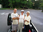
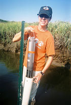
I met the research team at 6:15 AM at the Hollings Marine Laboratory (HML) loading dock. Anne Blair, a Principal Investigator, was there to see us off. Guy DiDonato, Associate Researcher for this project, had already loaded up the truck with the equipment we would need for our sampling trip to Village Creek in Beaufort, South Carolina. Beaufort is located on Port Royal Island, one of the large Sea Islands along the southeast Atlantic coast. Beaufort, like Charleston, still has many antebellum mansions and other historic buildings. I enjoyed fishing and exploring these same tidal creeks in Beaufort on camping trips with my dad when I was a kid. Our research team went into the creeks today to take water and soil samples to analyze in the laboratories at HML. We need to arrive at the site before low tide in order to get into the creek. I'm glad that we will be working in the marsh early in the day so it won't be so hot. Another team led by Angela Salisbury who works for Department of Natural Resources (DNR) left an hour earlier than our team. They are repeating the same sampling at a different order on Village Creek. They began an hour earlier so that our 'stomp' through the mud inland would not muck up their samples as the tide went out. Both teams worked together to process the samples back at HML. I was prepared with a book to read on our trip to from Charleston to Beaufort. I brought long pants for walking through the juncus in the tidal creek, a bag lunch, plenty of water, and sunscreen. After careful consideration, I decided on sneakers for the pluff mud hike. Other members of today's sampling team were Travis Washburn, graduate student at College of Charleston and Mark Tibbett, graduate student of South Western. Graduate students may conduct research at the Hollings Marine Laboratory if their advisor is a Principal Scientists at the laboratory. HML offers undergraduates a hands-on opportunity to work with the scientists in the field and in the laboratory. Sadie Drescher who works for the South Carolina Department of Health and Environmental Control - Ocean & Coastal Resource Management (SCDHEC-OCRM) also joined our team. That's quite a mouthful. I understand why researchers use initials instead of the names of the HML partner agencies. I was surprised that so many state and federal agencies are working together on the large problem of Oceans and Human Health. We parked the truck on the side of the road at Village Creek and prepared for the trek into the salt marsh. Village Creek flows through a rural area. There are only a few houses in the landscape. Guy made sure his team was supplied with the HML backpacks and coolers containing the equipment we would need for today's water and soil sampling. I also carry a digital camera, notepad, and drinking water with me. Our sampling supplies includes a cooler for water samples, pre-labeled sampling bottles and plastic bags, a core sample tool, a PVC pipe for taking pore water samples, and the sonde. The sonde is an instrument for monitoring water conditions in lakes, rivers, wetlands, estuaries, coastal waters, and the open ocean. The sonde is torpedo-shaped and has multiple sensors that record a range of water quality data, including: temperature, conductivity, salinity, dissolved oxygen, pH, turbidity, and depth.
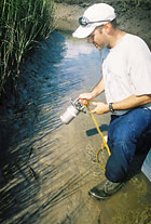
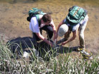
All of the sample collection bottles and plastic bags are dated and labeled with the order and reach number. Guy has taken samples from Village Creek for two years and knows the general location of all three reaches. We use a Global Positioning System (GPS) to find the exact location of each reach. The GPS acts like a compass pointing out a direct route to the reach. Guy had programmed the GPS with the exact locations of each reach before the trip. We sometimes had to ignore the direct route of the GPS to zigzag around the softer and deeper pluff mud. Once we reached the reach we pulled out a plastic bottle to collect the first water sample. We rinsed the sample bottle with the salt water in the creek and then filled it with water flowing toward us. This way we avoided the water we disturbed stepping into the creek. The filled water sample bottle went into the cooler. Guy pointed out the steeper bank of the creek had been washed clean of mud leaving only clay. We took the core sample from the other side of the creek where mud was deposited. The mud naturally sinks to the bottom of the creek on the lower side of the bank during high tide. This soil sample would more likely show any toxins in the water that had settled into the sediment. The metal core sampling tool is attached to a premeasured rope that is used to calculate a sampling spot on the bank three meters down from the high water mark. The high tide level is naturally marked by dead Spartina that floated up with the incoming tide and stuck to the grass at the level of high tide. The core sample tool is rinsed with creek water before and after each plunge into the mud. We carefully wiggled out the core sample to make sure it is intact. We took a surface soil sample near the core sample and placed it into a labeled plastic bag.
We also took a pore water sample using a PVC pipe pushed three centimeters (3 cm) into the mud. This plug is put into another labeled plastic bag. One last soil sample is put into the same bag at each reach to provide a composite or combined sample from this Village Creek site. We followed the same exact procedure to collect three soil and water samples from each reach.
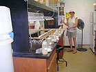
When we reached the middle reach, reach 2, we deployed the sonde. Guy and Travis worked together to carefully place the sonde at the lower part of the water column in the creek, but not so deep that it will drag into the mud with the changing tide. The time is recorded. Guy's research team will retrieve the sonde in exactly twenty-four hours. The research team pulled a seine to sample the marine life in each reach the following day. They also retrieved the sonde the next day. I was afraid I would not be able to maneuver through the pluff mud as well as the experienced researchers. I remember sinking so deep in pluff mud my dad had to pull me out. I was told to move through the mud quickly to keep from sinking deeply into the pluff. The mud gets softer and deeper closer to the creek. I did sink thigh deep in one spot. I struggled to pull myself out of the mud pulling on the Spartina and crawling out of the mud on my knees. What is the best way walk in pluff mud? I plan to begin my own investigation of this question. We finished our field work and headed back to the truck with the water and soil samples. The water samples are carefully stored in coolers in the truck bed. Everyone pulled off muddy shoes and muddy pants. I wore my long pants over shorts, but the shorts were wet from my dive into the pluff. I jotted a note to myself to bring an extra tee-shirt, a second pair of shorts, and wet wipes on our next creek sampling. Back to the lab Anne Blair met us at the loading dock and invited me into the lab to help process the water samples we collected today. Samples collected from the tidal creeks have to be carefully stored until they are analyzed. The rest of the research crew quickly began washing the boots, sneakers and other gear we wore into the tidal creek and preparing for the second part of the sampling trip to Village Creek the next day. I was so excited to actually work in the lab!
I was impressed by the procedures for processing the water samples. Every bottle and plastic bag we used to store the water samples were already labeled with the Village Creek reach numbers and date. We rinsed the beakers and tools we used to store our water samples from Village Creek with some of the water from the creek. This way the containers would not contaminate the samples with dust or tap water. Every step in the procedure had to be carefully followed always checking the labels on the bottles and the plastic bags. I was an excited but very cautious scientist! |
||||||||||||||||