| |||||||||||||||||||||||
|
|
Journals 2006/2007Elaine Paulishak
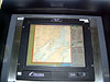
July 20, 2006 It's not the "Bridge of the Starship Enterprise" but it certainly is most impressive! The Bridge of the Fairweather is equipped with newest state of the art technology for navigation and control of all systems on the ship. The Fairweather has an Integrated Bridge due to the ECDIS (Electronic Charting Display Information System). All navigation systems are fed into the ECDIS. It takes position from the GPS and the DGPS (Differential Global Positioning System). The Fairweather's position in Kodiak is 57° 43.758 N and 152° 30.972 W. We have not been able to get underway due to a rather large storm that moved into the Gulf of Alaska.
The ECDIS has a GPS (Global Positioning System) input. It will chart the course from beginning to end. Compared to the raster (paper) charts, this electronic vector chart facilitates changes and receives input from a number of other systems such as the AIS (automated information system). The AIS can provide information on other ships which provides important data, for example, for collision avoidance. The ECDIS integrates the RADAR and ARPA (Automated RADAR Plotting Aid). The ECDIS can check the entire route and can indicate any problem areas. It is tied into steering and can be set to steer the ship's track (course).
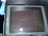
Taking the helm means to steer the ship. One must keep the rudders at correct pitch and at the same time keep the correct heading. It takes a lot of skill and practice to maintain the course when the steering controls are set to manual. There are two RADAR systems. One is X Band - higher intensity, shorter wavelength, tighter resolution and the S Band -- longer wavelength, longer distance, better to penetrate rain and fog and the shadow zone is smaller. Both can indicate CPA (closest point of approach) of other vessels and TCPA (time to closest approach).
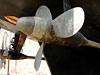
There are two engines which run two propellers attached to the bottom of the hull. One located starboard and the other attached portside. The props spin from 110 to 220 RPMs (revolutions per minute). Normal cruise speed is 180 RPMs at 10 foot pitch which will allow the ship to travel at 13 knots. Since the pitch of the propeller blades can be set, the greater the pitch of the blades, the faster the speed.
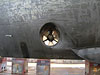
A bow thruster is mounted perpendicular through the bow of the ship which is used for docking. With all of these features, the Fairweather can make a complete turn in place or it can move perfectly sideways. This allows greater maneuverability as needed. These are a few of the amazing instruments found on the bridge of the NOAA Ship Fairweather. To be continued... Tomorrow. |
||||||||||||||||||||||