| |||||||||||||||||||||||||
|
|
Journals 2006/2007Elaine Paulishak
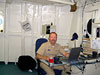
July 26, 2006 I woke up early to go up to the bridge. So far on this trip I had not seen what it looked like when it was really dark, since the sunset at 2300 and rose at approximately 0630. I entered the bridge at 0500 and the bridge was completely dark except for some little indicator lights on the instruments. The front of the bridge has a whole row of glass windows and when ships run at night they turn off the interior bridge lights. When the officers do a fix at their chart table; they use a little red flashlight type of device. It's like driving a car at night, all of the instrument screens are lit up but the rest is dark. It allows for better visibility. All ships have navigation lights attached to the top mast on the exterior of the ship. You can see this light at quite a distance; especially on approaching ships. As the ship approached Dutch Harbor, there was another ship approaching us. I observed as the officers read the radar screen and determined the CPA (closest point of approach) and the TCPA (time of closest approach). By this time, I could also determine our relative position. We would be within .2 of a mile!! Being within the mile limit, they followed standard operating procedure and called the CO and let him know what they intended to do. They changed the course to widen the distance between us and the other ship to acceptable parameters.
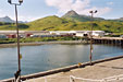
Prior to entering the bay, the deck crew were out getting the lines ready on the Bow. The brow (gangway) that had been partially disassembled was now re- assembled. At approximately 0800 we were moving into the harbor to the point where the ship would dock and the first order of business was to refuel. The fueling company had already been notified so they were ready for us. Docking was done in a very careful manner. It was rather amazing to see and feel the ship move sideways.
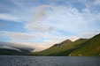
Dutch Harbor is the world famous port where fishing ships come in to unload their catch. It has been featured in TV documentaries about crab fisherman working in the Bering Sea. The population is small, only about 4,000 permanent residents; a lot of people move in and out as part of the fishing industry.
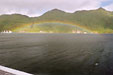
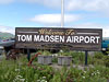
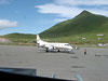
The port is connected to the city of Unalaska by a bridge. Its airport is considered to be one of the most difficult to fly into because of the high peaks. The area has an Aleut and Russian heritage. The oldest Russian Orthodox Church in the United States is located there. Historically, it is known for being another area bombed by the Japanese in WW II. One can see bunkers left over from that time. Bald eagles are prevalent in large numbers in the hopes of sharing some of the fishermen's catch. Dutch Harbor and Unalaska, Alaska were charming places to visit, with rich heritage and beautiful scenery. My NOAA hydrographic survey expedition ended there! I would fly out of the Tom Madsen Airport the next day!!
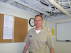
I would like to thank the ARMADA project for making this extraordinary experience possible. Many thanks are sent out to the Commanding Officer, CDR Andrew Beaver and the Executive Officer, LCDR EJ Van Den Ameele and all of the officers, Survey Techs, Scientists, Steward Dept., Electronics Tech, Engineering Dept., and Deck Crew for making my stay on NOAA Ship Fairweather both enjoyable and educational. Thank you for sharing your knowledge, pictures, PowerPoints, charts and your time with me. Your contributions to my experience will significantly benefit my students and my colleagues. May you have fair winds and following seas!!
|
||||||||||||||||||||||||