| |||||||||||||||||||
|
|
Journals 2006/2007Elaine Paulishak
July 23, 2006 On this expedition, the plan was to reach the Shumagin Islands and continue to collect data for updating nautical charts. On the previous day the MVP had been tested. The MVP (Moving Vessel Profiler) also known as the "fish" is used to determine the speed of sound in the ocean. It is deployed at the stern of the ship and then is pulled along as the ship covers its survey track lines.
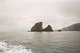
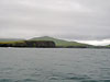
The other piece of equipment tested was the USBL (Ultra Short Base Line) Pole. The purpose of the pole is to indicate the position of the towfish. Since the pole has a transducer, it can communicate with the towfish which has a transponder. It provides a range and bearing in three dimensions needed to know its position relative to the ship. We reached the Shumagin Islands around noon on Sunday. As we arrived, the Fairweather personnel began immediately collecting hydrographic data by maneuvering the ship back and forth along predetermined survey lines. The lines run parallel to each other and to the contours on a map. As the ship "mows" back and forth along the survey area, the multibeam transducer is sending signals and the scientists in the plot room are receiving the data on the computer. As I entered the bridge, I was facing part of the Shumagin Islands known as the Haystacks; on the port side was Andronica Island and on the starboard side were the Nagai Islands.
It was especially exciting being on the bridge when Fairweather came to the end of a survey line and the ship made an almost complete 180 degree turn and went onto the next line in the opposite direction. I spent some time on the bridge practicing triangulation of our position on the raster charts using three land points from the radar. Everything that occurs on the bridge is logged and weather data is recorded every hour. I checked wind speed, direction and the wet and dry bulb hygrometer. In the plot room, the data being collected from the surveys was registering on the computer.
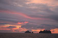
Later toward evening the clouds moved away and the sun once again was bright in the sky. At 2200 hours (10PM), the sun was still shining brightly. Sunset occurs in Alaska at this time of year at about 2300 hours (11PM).
Speaking of time, Alaska is in a time zone which is 4 hours earlier then home on the East Coast of the United States. For example, if its 10 PM in Alaska, then it would be 2 AM Eastern Standard Time. At sunset, the Fairweather continued to do surveying which persisted throughout the night. The Plan of the Day for Monday indicated that we would anchor in Porpoise Harbor at about 0700 in the morning. |
||||||||||||||||||