| |||||||||||||||||||||
|
|
Journals 2008/2009Roy Arezzo
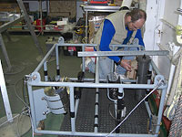
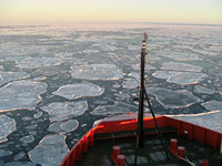
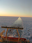
July 14, 2008 Folks are working around the clock now and with ice not as consistently thick as first reported we look to be ahead of schedule and should be on our first station site (station G of 5 station on our transect) between 5 and 6 a.m. The ice in the south is still thicker than the pancake ice we rolled through earlier and it is pretty loud against the hull as heard from the galley at mealtime. The sound at times resembles a passing train. Despite the noise, it is spectacular to witness. The last thing I saw tonight after 1 a.m. was P.I. Craig Smith and team Brazil working on the bottom camera, referred affectionately to as the "yoyo camera." The NBP technicians and scientists worked together to create a new frame for the camera, which, was set up and welded in Punta Arenas and rigged on the ship. It is quite the feat to rig this high tech gear at sea but with a full machine shop, the experience and skill of the scientists and the crew, it seems like we can make anything happen. Despite all the gear and talent much goes wrong and folks spend hours taking apart and refitting the equipment. The yoyo camera will be pulled near the bottom at each study site to take real time digital images of sea floor. As it moves it will be dropped down and retracted along the bottom, which is where I assume the name came from. There is a trigger that sets off a strobe and the 35mm camera lens when it makes contact with the bottom taking a high-resolution digital image of four square meter area. From the cable we can control how many times it makes contact and distance of the area we photograph. By creating a grid of the images, the data can be used for both qualitative and quantitative analysis of the seafloor. In addition to seeing what is on the bottom in order to give us a whole picture about the sediment we pull up in our coring instruments we can collect data on species diversity, detritus coverage and feeding rates.
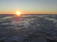
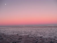
There are 26 deployments of the nine main instruments we sample scheduled for the first two days at our Station G, the furthest point south on the cruise. There are plans to core the bottom, check the water quality, collect images and trawl for plankton and larger organisms. There was much science talk today about order of operations once we are on station but the highlight for all was clear skies and the first sight of Antarctica near Adelaide Island. Sunset was around 2:30 p.m. and I was on the bridge and surroundings decks for the entire photo shoot. I was very excited to be witness to 360 degrees of amazing views. If a picture is worth a thousand words I should stop here and let my images say the rest.
|
||||||||||||||||||||