| |||||||||||||||||||
|
|
Journals 2008/2009Roy Arezzo
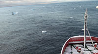
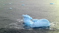
July 23, 2008 Transiting north again from Station B to Station AA. I took some time after our meal to head up to the bridge and take it all in. We passed Anvers Island to our east and at around 64° 17'S, 64° 13'W some of the fog dispersed long enough for a quick glimpse of spectacular glacier walls and ice peaks. To the west, a pair of small whales, possibly Minke, showed themselves briefly for a breath and a spout before disappearing. A point or so off the bow, a large leopard seal protruded its long neck out of the water to watch us go by; meanwhile, all around is open water dotted with bits of icebergs of interesting shapes, sizes and colors.
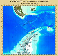
We arrived at Station B late last night around 2 a.m., staying long enough for the night watch to tackle 2 Box Cores, a Megacore and a CTD. We are not done at station B, but since it is on the way to AA we stopped to collect some samples that will need to be incubated up to five days before they can be analyzed. The plan is to come back and finish operations at Station B, culminating with the camera being removed from the "Yoyo" and rigged to the second Time Lapse Camera Tripod, which will live on the bottom at Station B for the next seven months. The first tripod was put down to the seabed at Station G and this event may bookend our trip as a final deployment. Each of the five approximately equidistant stations consists of about five square miles of ocean on the Antarctic Peninsula shelf with an average depth of around 600 meters, with some parts being as deep as 900 meters. Most continental shelves around the world have a depth of around 100 to 200 meters. According to Dr. Dave, Antarctica is unique in that the weight of the ice on the shelves created during glacial periods (as recently as 18,000 years ago) has weighted down the geomorphic feature and isostatically created a deeper shelf than most other places on Earth. The continental shelf is an important interface between land and ocean. On the first FOODBANCS project the team conducted a cross-shelf transect at three stations on nearly the same longitude as Station B. Station B is important in that it marks a central point along the peninsula and it is close to Palmer Station, a research station on Anvers Island, where long-term data are available for time-series comparisons. FOODBANC2 is a seasonal study, over a latitudinal transect, which will include data from three cruises, the previous cruise in February 2008, this one in July, and the next trip in February 2009 (summer, winter, summer). Station B is the only replicate station from the first study, with Station AA at our furthest point north and Station G at the southern end of our N/S transect. I am looking forward to seeing the difference in fauna from our trawl samples as we reach our northernmost station some time this evening.
|
||||||||||||||||||