
 | ||||
|
|
Journals 2003/2004Sarah Quan
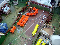
July 14, 2003 Latitude: 63º 50.314' N Longitude: 3º 47.153' E It is just after midnight and the sun is setting. We just finished dropping the first mooring. The process took just over an hour. I was responsible for hanging out on the bridge and taking down information on latitude, longitude, depth, and time as each component of the mooring was sent overboard. A mooring consists of 6 major components connected in line with rope and chain. The drop process begins about 2 km away from the drop point. The first component out is the Argos beacon, then about 14 floatation balls, then the sound source and its instrument pack, more float balls, an acoustic release, and finally when we are at the right spot over goes the anchor. All this time the ship is slowly moving to keep tension on the ropes so the components don't tangle. The length of the rope is adjusted so that each sound source hovers around a depth of 500-600 meters once it's deployed.  
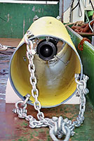
The instrument pack has a battery in it. Twice a day it powers up and produces a sine wave. That electric signal is sent to the sound source, which is a piezo electric ceramic sphere. A transducer converts that electric signal to a vibration causing the sphere to oscillate at 11000 Hz, which is too high. The ceramic sphere is placed inside a large steel tube whose length is carefully measured so that when the whole deal is placed in the water the resulting oscillation steps down to 260 Hz. This lower frequency sound is sometimes referred to as a pong instead of the more familiar high-pitched ping. This instrument pack and sound source are the meat and potatoes of the operation. The anchor is made from 3 railway wheels with a total mass of 800-900 kg. Their function obviously is to take the mooring to the bottom. Twice a day the sound source will emit a signal for 80 seconds. Later in the cruise we will deploy RAFOS floats the listening devise that will float freely in the current for 2 years collecting and storing data. When the time comes to retrieve the mooring components an acoustic signal is sent to the acoustic release, which separates itself from the anchor. The floatation balls, which have up until this point kept the mooring positioned vertically in the water column, now pull the system to the surface. The Argos beacon then sends a signal to the Argos Satellite system with its location. Later that day (13:25) Latitude: 65º 23.17' N Longitude: 2º 30.67' E Air Temperature: 14.9ºC Water Temperature: 13.1ºC I am periodically going to include the air and surface water temperature for some of the coordinates we pass through in hopes that it will mimic the competing deep-water bodies that meet at the Iceland-Faroe Front. Later today we will deploy the first of the Argo floats. As mentioned earlier the international goal is to deploy 3000 floats worldwide. There are presently about 600 of them out there. They are placed 300-500 km apart. They are subsurface drifters with no acoustic telemetry; they don't know where they are when they are down. They have a CTD on board for measuring conductivity, temperature and depth. They come to the surface every 10 days for 2 hours to transmit their position and CTD info. Then they drop back down to 1500 meters where they continue to drift freely with the current. They can last for up to 5 years. For locations of the 600 deployed Argo floats go to http://www.ifremer.fr/coriolis/ctd/maps/ctdmapprint.  |
|||