| |||||||||||||||
|
|
Journals 2008/2009Cheryl Manning
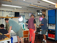
January 21, 2009 Drs. Robert Pockalny and Lewis Abrams work together in the geophysics lab on the deck directly above the main lab. Their job is to figure out where we should go to get the data necessary to answer the question.
Long before we left on this trip, the scientists had already figured out where to sail. In December 2006 and January 2007, they had sailed together collecting data in the South Pacific Gyre. Upon their return, they analyzed their data and decided the next step: to find a place where they could determine the relationship between both surface chlorophyll and distance from land and the number of cells found in the sediment beneath the seafloor. They needed a place where there was high chlorophyll levels and where they could vary the distance from land. There were two places where this could happen: the Equatorial Pacific and the South Atlantic. The South Atlantic is colder and has much rougher seas. Both factors make data collection more challenging. When the seas are rough, the surveys of the bottom are not as accurate and the deployment and recovery of the long core is more challenging. So the Equatorial Pacific is a better site but it is a big place. The sites need to be in areas that have high chlorophyll, thick sediments, and away from mid-ocean ridges and other topographic highs. One other complication is Exclusive Economic Zones or territorial waters. No sampling can be done in the EEZ. Finally, one has to decide on a definition of land. How big should land be to be considered significant enough to affect the organisms living in the sediment? Using some geometry, order of magnitude thinking, and geography, the scientists settled on anything bigger 10,000 square kilometers.
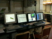
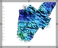
When on site, Rob looks for normal topography (abyssal hills, not seamounts) with flat-topped hills using Multibeam SONAR. This technology consists of an array of transducers on the bottom of the ship. Transducers both emit and hear sound waves. The sound waves strike an area about 100 m wide and then bounce back up to the ship. Computers on board the ship create a digital image of the seafloor when the transducers receive the returning sound waves. These computers also integrate the movements of the ship to give the best possible picture.
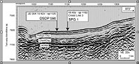
Lew examines the sediments. There needs to be at least 50 meters of sediment and it needs to look like it fell out of the seawater like snow onto rough mountain topography. There should be layers visible in the seismic profile. For his work, Lew uses a lower frequency, higher amplitude sound wave (think P-wave) that not only bounces off the surface but also penetrates the sediment cover. Differences in sediment characteristics (compressibility and density) cause the returning sound wave to refract or bend. This refraction shows up in the seismic profiles that the ships computers generate.
What we end up with is a good image that maps out the topography of the seafloor and a profile of the sedimentary cover. Now, the coring mechanisms can be deployed and hopefully, we end up with mud at the surface. Questions:
|
||||||||||||||