| |||||||||||||||||
|
|
Journals 2008/2009Steve Howard
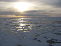
August 16, 2008 I began my "day" with the midnight sun for my watch. As I stepped outside for my chilly walk down to the science lab, I realized that we had hit our first patches of Arctic ice. Some call this type of ice "cheese ice", which are thin sheets of first-year ice (ice that has not built up in thickness over a number of years. As the day wore on and we press farther north, we encounter more and thicker ice, which by the end of the day covered most of the sea's surface. It is a beautiful and surreal landscape, with brilliant blue ice swirling through dark water and the reflected sunlight creating golden pools of light in the melting water pockets. I find myself staring at the sea endlessly these days, as each few minutes brings us to new shapes and structures in the ice passing by. The Healy plows through this ice easily, but makes a lot of noise and vibration as the ice hits the hull and either scrapes against the side or is pushed underneath the bottom to pop up on the other side. Depending on where you are on the ship, this can range from a dull bump to a deafening pounding. I'm beginning to get used to this background noise, and it's almost becoming reassuring. I wonder what it will be like trying to sleep to it.
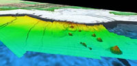
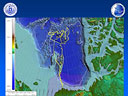
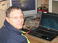
I wanted to spend some time describing the seafloor mapping mission which is the primary reason we are out here. It's very complicated, with scientific, legal, and geopolitical implications. So, I'm shooting for the barest of a summary here. In a nutshell, nations are given exclusive rights to resources up to 200 nautical miles from their shoreline based on United Nations charter agreements. However, if nations can prove that their continental shelf extends outward in a "natural prolongation," they can extend their sovereign rights over resources of the seafloor and subsurface beyond the 200 nautical mile limit. Essentially, we're talkin' oil here, folks. The United States and other nations with land in the Arctic Circle are all actively trying to understand the shapes of their continental slopes so they can identify these prolongations and extend their rights to these areas. That's where this project comes in. Using the Healy's multibeam echo sounder system, which bounces a swath of echo-sounder "pings" and "chirps" off the sea floor and back to the ship, Larry and his team of scientists are creating detailed 3-dimensional maps of previously unmapped areas of the Arctic seafloor to see where nations may extend out their continental shelf and claim rights to resources. Essentially they are using sound to see! In addition, this data can help scientists better understand climate and circulation models and fisheries habitat. As I watch these scientists go about their mapping, I feel as though I am witness to a very important piece of history. As the Arctic warms and human exploitation of the resources in the region increases, this data will be at the forefront of major geopolitical decisions.
PROFILE:
|
||||||||||||||||