
 | |||||||||||||||||
|
|
Journals 2008/2009Steve Howard
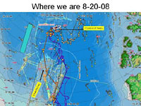
August 20, 2008 Today I thought I'd give an update on where we are regarding the seafloor mapping mission. Having come up and across the Chukchi Cap plateau, we are currently mapping along the northeastern-most extent. The idea is to better understand how this region is connected to the Chukchi Cap. We have come across an elevated region that has not been well mapped before, and are spending some time today mapping back and forth along this region to more clearly define it. After this, we will follow seafloor features eastward for a time before heading back south toward Barrow.
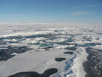
The air temperature has warmed up a bit and clouds have come in, reducing the visibility and giving a ghostly white feeling to the ice as we plow through it. I'd assumed that the farther north we go, the more and thicker the ice but I see now that the truth is much more complex and dynamic. Ice conditions vary by the hour, with some sections where the ice is so thick we have to back up and ram forward to get through, and then an hour later we come to areas where the ice is much thinner and large "lakes" of open water lie before us. It's impossible for me to survey this scene without wondering what it will be like 20 years from now. The climate is changing so rapidly in the Arctic; I am seeing an ice landscape that may be all but gone when my own child is grown. I am so grateful to be up here, and to be one more witness to this place. The scientists on board the Healy are all working vary hard to understand the Arctic region and hopefully mitigate our mismanagement of the planet with meaningful data and research-based solutions. Working as a classroom science teacher, I know how easy it is to become so focused on my 180 kids per day and managing their learning environment that I lose site of the broader picture of science as a process taking place all around me. It's refreshing to be our here and to have the time to "breathe in" the science part of being a science teacher.
PROFILE:
|
||||||||||||||||


