| |||||||||||||||||||||
|
|
Journals 2009/2010Jonathan Pazol
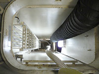
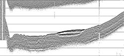
August 18, 2009 Watch has been fairly uneventful, which gives us all some time to relax. I've gotten a chance to talk to many people and find out what they're working on and who they are. It's really refreshing to meet people who are bigger science geeks than I am - and for those of you who know me, that's pretty extreme. But, these people are not anti-social hermits stuck in labs somewhere. They do field work on ships, in the mountains, off the coasts, etc. in places all over the world. In addition, they have interests from rugby, to Newfoundland folk music, to surfing, to autoharp playing, and even to building hovercrafts. On any night our random music selection on watch includes Aaron Copland, Emerson Lake and Palmer, Mexican guitarists, and last night a medley of Leonard Nimoy and William Shatner songs (it was very early in the morning for those). Today the Healy spent a large amount of time in a "holding pattern." The Louis was having problems with its seismic equipment and had to stop in an area of open water to fix it. In the mean time, we continued to collect data and used the time to do some maintenance. As described in previous entries, the sea floor is mapped in a variety of ways. The multibeam echosounder gives a view of the topography of the surface. Other instruments on the ships are called sub-bottom profilers, because they send out sound waves to generate a cross section of the sediment layers on the ocean floor. This sediment is made up of silt, mud, remains of organisms, etc. that have settled in layers on the bottom. In some regions of the Arctic, the sediment gets deposited at the rate of 50 cm (about 20 inches) every 100,000 years. The Healy sub-bottom profiling system is called a Knudsen system, or "chirp" system because of the sound it makes when the signals are emitted. It sends out a range of sound waves between 3 - 6 kHz (kilohertz) at one time, and that chirp can be heard throughout the ship. The instrument is located at the very bottom of the ship. To reach it, you would have to climb down a small shaft between the fuel tanks that needs special ventilation before anyone can enter.
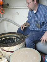
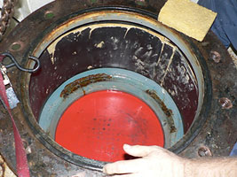
The instrument that makes the chirp is called a transducer and is placed in a well that sits right at the water level. The only thing separating the transducer from the ocean is a 4-6 inch layer of plastic (its color is actually red) that allows the sound waves to travel through.
When the seismic signal is sent, it is able to penetrate about 75 meters (about 245 feet) into the sediment layer - this is after is has travelled through the 3800 meters (2.3 miles) of water. The signal is picked up and once the data is analyzed, a cross section of the sediment layer is produced.
From these cross sections, geologists can figure out the profile of the sea floor. They are able to look at the layers and see where certain processes, such as pockmarks, gas escape, slumpings (sediment slides), etc. occur. |
||||||||||||||||||||