| |||||||||||||
|
|
Journals 2009/2010Jonathan Pazol
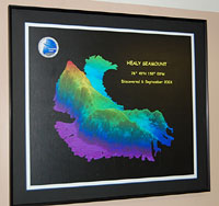
August 25, 2009 Well, for the first time in 21 years I was not present to greet my new students at West Leyden High School in Northlake, IL, and it is a strange feeling. I have left them in the very capable hands of a former AP Biology/Biology teacher, so I know they will be fine. I prepared an introductory video and Power Point presentation for them - showing me in a winter coat in July, but it is not the same as being there in person. I am very thankful to them, to the Leyden High Schools Administration and Board of Education, to the ARMADA Project and National Science Foundation, and to my family for supporting me on this expedition. I truly appreciate it. Something else new happened today - the discovery of a previously unknown "seamount." A seamount is an ocean floor feature that rises at least 1000 meters (about 10,000 feet) above the surrounding sea floor. During a 2003 expedition on the Healy another seamount was discovered, and it was later named Healy Seamount. A Fledermaus image of it hangs in the Science Lounge.
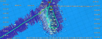
Early this morning, while following the "purple line" on the multibeam Map Server display, we noticed that the ship was approaching a contour line that showed a rise on the sea floor of about 200 meters. A contour line is what is used on land topographic maps to show changes in elevations, and this one just looked like an outlined oval. We specifically diverted from our planned route with the Louis in order to investigate this contour more closely. These lines were recently placed into the Map Server program by geophysicist John Hall of the Geographic Survey of Israel. (John loves to take pictures of other people, and it is difficult to get a photo of him without a camera up to his eye, so the picture below is quite rare). Part of his work on this trip is to take data from a 2002 Russian Federation Navy contour map, digitize it, and make it the same scale as the IBCAO (International Bathymetric Chart of the Arctic Ocean) map that we are using. The Russians compiled their data from large numbers of different types of measurements taken from icebreakers, ice stations, and even submarines. While they had indicated that there was a change in sea floor elevation, there was nothing suggesting that this was an actual seamount.
Sure enough, the feature located at approximately 81° 30.25 N and 134° 30.70 W met the 1000 meter requirement for a seamount. It's a very exciting discovery and will be added to the IBCAO map in future revisions. As far as naming it, everyone around here is offering suggestions, but I do not think it will be called "Pazol Seamount" anytime soon (recent naming conventions do not have seamounts named after living people - plus I am "just along for the ride"). Larry Mayer will fill out documentation giving the precise location, height, name suggestion, etc., and then it will be officially recorded.
|
||||||||||||