
 | |||||||||||||
|
|
Journals 2009/2010Jonathan Pazol
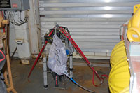
August 9, 2009 My days now start at midnight. One of the projects scheduled for earlier this evening was the deployment of a CTD (Conductivity, Temperature, and Depth) probe. This piece of equipment is lowered into the water and takes measurements down through the water column. It is vital for determining the speed of sound through the water, which is affected by these three conditions. Since the majority of the Healy mapping is done through sonography (sound waves), this is crucial. Conductivity, how much electrical current can travel through the water, is measured by collecting the amount of salt (salinity) in the water. Since salt is charged (ionic), it affects the electrical current. Salt also affects the density of the water as well. Temperature and depth are also important features for the scientists. Deploying the CTD allows them to take baseline readings and to calibrate their equipment. The probe was going to be lowered about 3500 meters - about 150 meters from the sea floor. At that depth, the pressure is very intense. To show that, the scientists allowed science party and crewmembers to perform an additional demonstration. They had a pack of polystyrene (Styrofoam) cups and people decorated them in various ways. Using a crewmember's mesh laundry bag, they filled it with the cups and attached it to the side of the CTD probe. If you look closely at the photo, you can see part of the word "Leyden" in blue and gold. It takes about three hours to lower and raise the probe, so we'll see the results later. On other cruises, people have lowered polystyrene mannequin heads. We thought that would be a great idea to decorate them, and then people could hang them from their car rear view mirrors.
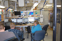
On every eight-hour watch, there are at least five people assigned. One person is responsible for processing data from the Multibeam Sonography equipment. One person is responsible for processing seismic data, which we will start collecting once we meet up with the Canadian icebreaker. Two people are assigned as general watch people. They are either in charge of specific duties, like calling up to the bridge to tell the officers which way to steer the ship, or to work on their own experiments. The fifth person has been designated as a "blog" person - that's me. There are three of us with this duty during the day. Once is Chris Hedge, the teacher from Indiana, and the other is Barbara Moore, who is affiliated with the U.S. State Dept. Also, Larry Mayer and Captain Andy Armstrong, the co-chief scientist from NOAA and CCOM (Center for Coastal Oceanographic Mapping) split the day into twelve-hour shifts. During our watch, we were given an introduction to the mapping equipment. Ten different computer screens and a video monitor display different programs involved in the data collection. One of them has a watch log, on which events, problems, and comments are recorded. These include such things as shift changes, when equipment or probes are dropped off the ship, or when sensor readings are not responding in the right way. Others show maps and data collected from the multi-beam equipment and exactly where the ship is located. One has a program that shows a picture of each individual return from the multibeam sonar. Another monitor keeps precise data on the ship's position, how fast it is going, how much it is pitching and rolling, etc. The video monitor shows live feeds from the fantail on the back of the ship for equipment deployment, the Aloft Conn from the top and bow of the ship, and we even saw a feed for a baseball game (but that did not stay on for more than a few seconds).
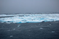
Because of delays with meeting up with the Canadian icebreaker, plans were changed and the ship moved into position to do some mapping on the Northwind Ridge. Coordinates and directions were given to the bridge, so that the crew would know where to guide the ship. As the mapping data was displayed, the ship was guided back and forth to collect data about the sea floor and to "fill in holes" on the map from previous expeditions. The scientists were very impressed with the way in which the "driver" turned the ship carefully to avoid getting data that was too scattered and not useful. The other focus of the night was to find the ice edge, so that we could be ready to meet the Canadians. Just after 5 am, I was looking at the monitor from the Aloft Conn and spotted a white line on the horizon in the distance. Sure enough, it was ice - the first we've seen. On the log, I got credit, so I actually felt useful (at least a little). Right before we sailed into it, I went out on the deck and took some pictures. The ice is white with some deep blue features. Because it was "dark" out - as least as dark as it gets this time of year, it may not be apparent in this picture. I am told that on sunnier parts of the day when we are in the pack ice, the contrast is really striking.
As the ship hits the ice, there is a rumbling sound and a slight vibration. It is a little disturbing at first because my only "experience" with ships and ice are Titanic related. After a while, I stopped noticing it, and in fact, I was told that later that morning, we actually had to back up and ram through a patch. I slept right through it. If, and when, we encounter large ice ridges, I am told this probably won't be possible. Once watch was over at 8 am, I had "dinner" (breakfast to most other people) and went to sleep. The rest of the day was spent adjusting to the schedule change, talking to various scientists about their work, and editing yesterday's journal entry. It's been a long time since I had to do any writing during the middle of the night, so excuse any mistakes. |
||||||||||||


