| |||||||||||||
|
|
Journals 2006/2007Miriam Sutton
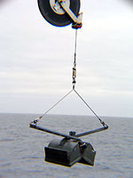
August 10, 2006 AM Location: Makkovik Bank (55° 18' 05.38" N, 57° 55' 42.59" W) Today was "Grab and Shoot" day. The coring pipe took a rest today while the bottom sampling and photography took center stage. The CCGS Hudson transited to Makkovik Bank overnight and the seismic equipment was hauled in and secured on deck during the day and the coring pipe remained bolted to the starboard side of the ship. Afterwards, the scientists and crew began lowering "grab" equipment and underwater camera gear to the seafloor. The grab equipment is designed to be lowered to the seafloor where the "grabber claws" settle into the seabed. A crane operator then reverses the winch which causes the grabber to close around the captured seabed sediment. (See Grab equipment photo below.)
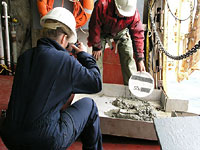
The captured seabed is then placed in a metal bin where the scientists can code each sample and make a photographic record of the sediment. (See Sediment Photo below.) The scientists also collect samples from each grab site and catalog it as one of six types of sediment. These six categories include: clay, silt, sand, gravel, cobble, and boulders. The sediments grabbed today ranged from clay to gravel.
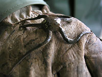
Occasionally, a few sea "critters" get captured by the claw. These are also recorded in the scientists log and then they are released. (See Brittle Star photo below.)
Today's activity: (Ask an adult to supervise you near the water during this activity.) Make a "grabber" using a metal can attach to some rope or strong fishing line. Toss your grabber into a local pond or stream while you remain on shore. Let the grabber sink to the bottom before pulling it along the bottom and toward you and your assistant waiting on shore. Observe your "capture" and discuss your discoveries. What type of sediment did you capture? Were there any critters captured? Can they be identified? Word of the Day: Starboard REMINDER: Record today's Sea Surface Temperature (SST) and the Air Temperature on the data table you created from the August 05 journal entry. |
||||||||||||