
 | |||||||||||||||
|
|
Journals 2006/2007Miriam Sutton
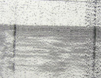
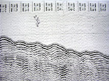
August 23, 2006 AM Location: Slope off Saglek Bank (58° 50' 0.98" N, 59° 01' 50.24" W) The scientists have been intrigued by some of the seismic images being created during our most recent 36-hour seismic survey. The survey is being conducted in a region of the Labrador Sea with depths between 2000 and 3000 meters. The hypothesis for seismic images at this depth is a relatively smooth sediment surface with lots of horizontal layering below. Sediment that settles in the deep ocean is usually undisturbed by wind-driven waves or currents at the surface. Even fierce storms do not generate enough energy to create disturbances in sediment deeper than 2000 meters below the sea surface. However, the images being recorded by the seismic equipment today indicate several regions of disturbed sediments in this deep water. Many sections appear to have "sediment waves" or "sediment ripples" similar to what you might see on a wind-blown seashore or desert, only much larger in scale. (See Sediment Wave photos below.)
These waves and ripples provide evidence to the scientists that some type of energy is being transferred from the deep water to the sediment deposits along the base of the slope off of Saglek Bank. The most likely suspect is a deep water ocean current known as the Western Boundary Underwater Current (WBUC) which flows along the western boundary of the Atlantic Ocean basin. The WBUC is actually part of the North Atlantic Deep Water current (NADW) that flows from the Polar region toward the equator. The NADW is one of several deep water ocean currents that circulate water between the Poles and the equator and around the world. This deep ocean circulation system plays a key role in regulating Earth's global temperature. The deep water currents in this ocean circulation conveyor system are driven by differences in density rather than the wind. Variations in seawater temperature and salinity change the density of seawater. Cold, salty seawater is very dense and sinks. The energy from the deep water conveyor system pushes the cold water current along the seafloor, causing sediments to be disturbed and transported in the direction of the current. (See NADW Circulation Illustration below.)
Today's Activity: Locate a world map and identify the five major oceans of the world. Observe the size of each ocean, noting the largest ocean to the smallest ocean. Next, look more closely at the Atlantic Ocean and place your finger on the equator in the middle of the Atlantic Ocean. Think of the seafloor beneath the ocean as a basin (like a sink basin) that is filled with water from the Atlantic Ocean. Note which continents lie to the left (or west) of your finger and which continents lie to the right (or east) of your finger. Locate the region on your map where the Western Boundary Underwater Current for the Labrador Sea would be located. Word of the Day: Intrigued REMINDER: Record today's Sea Surface Temperature (SST) and the Air Temperature on the data table you created from the August 05 journal entry. |
||||||||||||||


