Journals 2006/2007
Miriam Sutton
Newport Middle School, Newport, NC
August 17, 2006
Bad Luck-Good Luck
AM Location: Saglek Bank (58° 39' 06.59" N, 62° 07' 31.25" W)
PM Location: Saglek Bank (58° 45' 27.00" N, 61° 52' 08.02" W)
Sea Temperature: 6.4° C
Air Temperature: 11.6° C
Hydrospheric Conditions: Calm seas and gentle swells continued throughout the day
Atmospheric Conditions: Clear skies from morning until an hour before sunset when clouds began accumulate
Wind Speed/Direction: 20 knots/W switched to 10 knots/S
One man's bad luck can bring a blessing to others.
For the third day since departing from Newfoundland, we were in sight of land. This morning we slowly steamed into the fjord which leads into Saglek Bay with our rescued fishermen bobbing along behind the CCGS Hudson. The views inside the fjord were astonishing! Two large cliffs adorned the fjord from either side while icebergs drifted aside the entrance like patrons waiting outside the theatre. As the CCGS Hudson entered center stage, my camera was on the verge of over heating. Once covered completely by glacial ice, these ancient rock layers now reveal the violent tectonic history that folded and shaped this mountain range millions of years ago. (See Entrance to Saglek Bay photo below.)
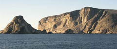 |
Entrance to Saglek Bay
(Photo: Miriam Sutton) |
The glacial history is still evident although the ice only remains in much higher elevations. Glaciers leave calling cards when they retreat, or melt, from an area of land. The massive weight of the glacier compresses the land beneath it and abrades and erodes landmasses as the ice moves back and forth seasonally. When large volumes of ice become trapped in a depressed area of a mountain top, the ice slowly melts and abrades the underlying rock. This results in a land feature known as a cirque. (See Glacial path and Cirque photo below.)
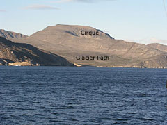 |
Glacier Path and Cirque left by Retreating Glacier (Photo: Miriam Sutton) |
Today's activity: Place an ice cube on a plate or small saucer. Allow the ice cube to melt at room temperature for several minutes. Observe the motion of the ice cube as it melts. Based on your observations, explain to a friend how cirques are formed by melting glaciers.
Word of the Day: Abrade
REMINDER: Record today's Sea Surface Temperature (SST) and the Air Temperature on the data table you created from the August 05 journal entry.
|


