
 | |||||||||||
|
|
Journals 2006/2007Miriam Sutton
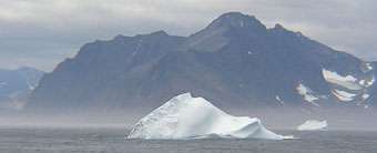
August 16, 2006 AM Location: North of Saglek Bay (59° 18' 43.22" N, 63° 13' 04.97" W) Science was unexpectedly put on hold for another day as the CCGS Hudson was assigned a Search and Rescue (SAR) call for a fishing vessel stranded north of Saglek Bay. Safety on the water is the Coast Guard's first priority so the research schedule was pre-empted while our vessel steamed toward Saglek Bay. We arrived by mid-morning and the FRC was launched to navigate the shallow coves and locate the fishing vessel. The ship's engineers joined officers and crew with the equipment and provisions needed to repair the fishing vessel's engine and to provide the fishermen with some food and water. While we waited on a report from the FRC crew, entertainment was provided by several icebergs that had traveled down the Labrador Coast and were bobbing between our ship and the shoreline. The rugged Tourngat Mountains provided a magnificent contrast to the smooth icebergs that were traveling south along a section of Labrador's coast known appropriately as "Iceberg Alley." (See Icebergs and Tourngat Mountains photo below.)
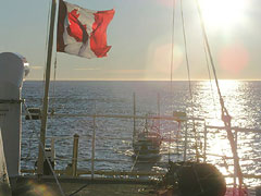
The CCGS Hudson maintained contact with the FRC and fishing vessel throughout the day and it soon became apparent that the fishing vessel would have to be towed back into the harbor at Saglek Bay. (See CCGS Hudson to the Rescue photo below.)
Today's activity: Locate a map showing ocean surface currents. Find the northeastern coast of Labrador on the map and note the name and direction of the current flowing past this coastline. Discuss with a friend why you think the northeastern section of Labrador's coastline is known as "Iceberg Alley." Word of the Day: Provisions REMINDER: Record today's Sea Surface Temperature (SST) and the Air Temperature on the data table you created from the August 05 journal entry. |
||||||||||

