| |||||||||||
|
|
Journals 2006/2007Miriam Sutton
August 30, 2006 AM Location: Cabot Strait (47° 20' 48.65" N, 59° 27' 45.90" W) The CCGS Hudson crew hosted a bar-b-cue cookout yesterday afternoon as we continued our transit of the Strait of Belle Isle. The waters along the strait were flat calm during our feast and through the evening hours. After eating, the scientists and the crew shared sea stories as the sun set over Labrador and the moon cast its reflection on the water's surface. It was a most beautiful night at sea! (See CCGS Hudson reflection photo below.)
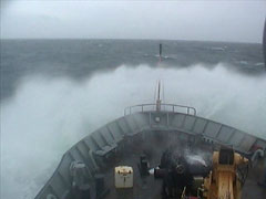
During the night, the CCGS Hudson continued her journey toward the North Atlantic Ocean by way of Cabot Strait. Cabot Strait lies between Newfoundland and Nova Scotia and provides a southern gateway to the St. Lawrence Seaway. I first noticed the loss of tranquility from my bunk as my body began to sway heavily during the night. I awoke to the shudders that resound from a large breaking wave striking the beam of the ship. I began to notice the cadence of the ship as it plied through the high seas and quickly surmised the steady rhythm of 4 to 5 swells followed by a slight lull in the ship's surges. I constructed my hypothesis: The CCGS Hudson is battling the remnants of Tropical Storm Debby that was swept out to sea earlier this week. I grabbed my video camera and headed for the bridge to make my observations. (See Waves Breaking over Bow photo below.)
What a difference in 12 short hours! After watching the waves break across the ship's bow and inquiring with the officers at the bridge, my hypothesis was confirmed and correct. Once again, Newton's First Law of Motion stands firm: Molecules in motion will remain in motion until acted upon by an outside force. In this case, the water molecules were set in motion several days ago by the circulation and winds associated with Tropical Storm Debby. These waves and swells have traveled hundreds of miles across the North Atlantic before meeting the bow of the CCGS Hudson. So far, the Hudson is handling the heavy seas beautifully. I can't say as much for the Canadian scientists, however, as most have been tucked away in their cabins for much of the day. Hopefully, the seas will subside in time for the recovery of the Ocean Bottom Seismometers off Sable Island tomorrow morning. Today's Activity: June to November is identified as Hurricane Season for the Atlantic Ocean. Hurricane mapping charts are available from many local merchants. Use a hurricane mapping chart to plot and track the progress of tropical storms and hurricanes throughout the season. Practice making storm track predictions based on the data points you have plotted and then follow the meteorology reports to see if your predictions were correct. Word of the Day: Cadence REMINDER: Record today's Sea Surface Temperature (SST) and the Air Temperature on the data table you created from the August 05 journal entry. |
||||||||||