
 | |||||||||||
|
|
Journals 2006/2007Miriam Sutton
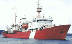
August 5, 2006 AM Location: St. John's, Newfoundland (47° 30' 27.25" N, 52° 49' 29.33" W) Welcome to the Canadian Coast Guard Ship Hudson (CCGS Hudson, see photo below)! Join me as I voyage with a team of scientists from the Geologic Survey of Canada and the Bedford Institute of Oceanography on a Canadian research vessel. Our vessel is under the direction of Commanding Officer Gary Saunders and his crew of thirty-five Coast Guard men and women. CO Saunders has the Hudson maintaining a gentle, peaceful sway as we depart from St. John's, Newfoundland, via a fjord, on our way to the open waters of the North Atlantic Ocean. It is a foggy, drizzly day in Newfoundland and, combined with the sway of the research vessel, the setting is providing a nice transition from my hectic airline travels between eastern North Carolina and Newfoundland, Canada.
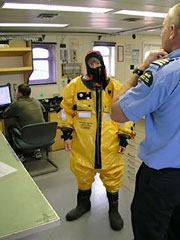
During my research experience, I will be providing a daily activity and a word of the day. In doing so, I encourage my students (as well as adults) to engage in the learning process as we journey along the continental margin and slope of the Labrador Sea. I have been welcomed aboard with a tour of the CCGS Hudson from the ship's Chief Officer (Brett Reiben) and he advises me on many safety precautions established within the Coast Guard vessel's protocol. One of the key concerns for a vessel traveling in the Labrador Sea is contact with the icy cold water. The average sea surface temperature is under 8° Celsius at this time of year. (That's about 46° F.) As part of my orientation, Officer Reiben instructs me in the fine art of "Survival Suit at Sea." (See "Survival Suit" photo below.)
After my ship orientation, I begin to learn more about the team of scientists I will be working with for the next month. The Chief Scientist is Calvin Campbell and he is joined by a cohort of 18 scientists and technicians. The mission of this research cruise is to collect sediment core samples and seismic data that will provide a geologic record of offshore seafloor conditions along the margin and shelf of the Labrador Sea. This information will assist Canadian constituents who may be interested in future offshore development. Knowing the stratigraphy and stability of the seafloor sediment can assist developers in pinpointing appropriate development areas that will not jeopardize deep-sea habitats or seafloor sediments that may pose geohazards based on their topography or instability. As a member of the scientific crew on the CCGS Hudson, I will assist in a variety of experiences that will help me learn more about the research techniques and equipment associated with sediment core sampling and seismic sampling of the seafloor. So, welcome to my adventure in the Labrador Sea. Today's activity: Prepare a data table to record the daily Air and Sea Surface Temperatures that I will record each day. Consider creating your table using spreadsheet software, such as Microsoft EXCEL. The total number of days that I will record data is 28, beginning with August 5, 2006 and ending with September 01, 2006. Once you have your table created, go ahead and enter today's data. Also, make a prediction about the temperatures you think Ms. Sutton will observe during her research cruise in the Labrador Sea. Record your predictions somewhere on your data sheet. Make yourself a reminder to record the daily air and sea surface temperatures during Ms. Sutton's adventure at sea. Word of the Day: Fjord (Look up the words highlighted in the journal each day and build your vocabulary about this unique region of the world. Construct a sentence using the word or share your new vocabulary with others.) |
||||||||||

