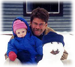
I teach science and geography at Polson High School on the Flathead Indian Reservation in northwestern Montana. Our school has approximately 550 students, many of which are Salish, Kootenai, or Pend d1Orielle Indians. Although each of the tribes is culturally unique and has its own belief system, they all share a deep respect for their natural environment.
For thousands of years, "The People" have depended on the land and waters of this remarkable landscape for food, shelter, and inspiration. Always planning for seven generations ahead, this sustainable approach has made Polson a great place to live for everyone, so much so in fact, that I have made the area my home for the past 20 years.
Before that I worked as a geologist prospecting for minerals in Alaska. Mostly this consisted of searching for sulphide deposits that contained copper, lead, zinc, tin, silver, and of course, gold. After magnetic and gravity surveys gave us a general idea of where to look, it would be left to my company1s geologists to tramp around mapping and looking for interesting structures and "colors." This involved lots of mountain climbing or tundra walking depending on the job.
One time, I did both, and in the dark no less. We were looking for a tungsten-bearing mineral that fluoresced a gorgeous neon-blue color under ultraviolet radiation. Picture my partner and myself stumbling around a mountainside shining our black lights (UV lights) on the rocks while trying to avoid falling off a cliff, or bumping into a grizzly bear. Needless to say, it was quite an adventure.
And that is exactly what I aim to do in my teaching; that is, I want my students to experience the spirit of discovery that is the essence of scientific and geographical exploration. Put another way, I help them parcticipate in the adventure of science.
For after all, that1s how I try to live. I have worked the past two summers, for example, as a biologist conducting wildlife assessments in Alaska for the U.S. Department of Agriculture. These jobs have allowed me to see the polar bears and Snowy owls along the frozen sea at Barrow, as well as the thousands of fur seals and sea birds on St. George Island in the Pribilofs.
But I can1t wait for the arrival of every summer to play scientist; therefore, all of my students are required to conduct their own scientific investigations too. Projects range from research in environmental and earth science to physical and cultural geography. I also try to get my students out into the field as much as possible.
First and foremost, I help my students get to know their own community. Science field trips to study the grasslands and wetlands of the Mission Valley, Flathead Lake, and the conifer forests of the Mission Mountains are routine. In geography, we go to numerous cultural events such as powwows and river honorings that are hosted by the tribes.
However, sometimes it1s desirable to try something a little more dramatic. To that end, over the last several years I have taken students to meet firsthand indigenous cultures such as the Tarahumara that inhabit the Baranca de Cobre (Copper Canyon) in Mexico, and the Bri Bri who live in the lowland rainforests of Costa Rica. We also studied the Sonoran Desert thorn-shrub and the Gulf of California marine ecosystems.
Perhaps most rewarding have been our trips to monitor nesting Leatherback Turtles at the Pacuare Nature Reserve in Costa Rica. The students work side by side with biologists collecting valuable data that will hopefully help save this endangered species. We work, by the way, at night since this is when the female turtle comes up on the beach to excavate her nest and lay about a hundred eggs. The sound of the brisk wind and breaking waves accompanied by the screams of the Howler Monkeys and the drone of a billion insects rising from the rainforest make it a fairly intense experience- forming an impression that should last for a lifetime.
Even better, my students share what they have learned with their peers in the local Costa Rican high schools in the hope that they will inspire similar conservation efforts among what surely must represent the turtles1 future survival. And on every trip we spend a few days restoring a little piece of the rainforest tree by tree.
Plainly put, doing science and geography like this is meaningful and fun. So when I learned about TEA, I knew I had to join the adventure that this program promises to provide. Indeed, my parcticipation in TEA will probably make me feel like a student again, or as T.S. Eliot observed:
We shall not cease from exploration
And the end of all our exploring
Will be to arrive where we started
And know the place for the first time.
Hope to see you out there!

Collaborative Research: CTD/Hydrographic and Underway Service Measurements for the Shelf-Basin Interactions Phase II Field Project
Dr. James Swift
The Scripps Institute of Oceanography
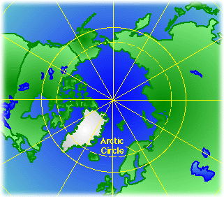
My quick response to TEA's invitation to work on an icebreaker this summer was simply the following: Sign me up, and ship me out! And in my mind, I'm already up there. Up there, generally, is the Arctic Ocean north of Alaska. It's part of the Western Arctic Shelf-Basin Interactions Program sponsored by the National Science Foundation and the Office of Naval Research.
The goal of the Shelf-Basin Interactions (SBI) program is to provide a clear understanding of the physical and biological connections between the western Arctic Ocean's rugged underwater landscape of shelves, slopes, and deep basins. Indeed, the general circulation of the seawaters at the top of the world still remains much of a mystery today. In the Arctic Ocean, cold, nutrient-rich Pacific waters meet the warmer and saltier seawater of the Atlantic. The complex mixing of these waters is in turn affected by the topography of the sea floor as well as the motion of the sea ice and wind.
Our focus is to gather as much information as possible about the Arctic's water circulation as well as its geochemical and biological cycles. Although survey work is among the least glamorous of oceanographic endeavors, it is only through the careful collection of data that we can accumulate knowledge of the distributions, gradients, and changes of water properties that help us establish a base line from which we can make comparisons in the future. While the world debates the causes of global warming, I consider myself fortunate to be involved in an intensive, long-term research effort that may some day shed some light on this problem since climate shifts are expected to show up in the polar areas first.
So it's exciting to be working with Dr. James Swift of the UCSD Scripps Institution of Oceanography. Jim is an oceanographer interested in ocean measurement and interpretation that specializes in studying the physical characteristics of the Arctic Ocean waters. Along with Dr. Louis Codispoti of the University of Maryland's Horn Point Marine Laboratory, he leads the SBI team which supports the project's measurements of seawater temperature, salinity, dissolved oxygen, nutrients, and chlorophyll. Because this cruise will concentrate almost entirely on these kinds of measurements, Dr. Swift was asked to lead it; however, Jim will not be focusing just on what the water properties are at any given location, but rather he'll be trying to assemble a coherent depiction over the entire SBI study region.
In the context of the overall SBI program, which is oriented more to examining processes, these quantities are called service measurements. The cumbersome "Collaborative Research: CTD/Hydrographic and Underway Service Measurements for the Shelf-Basin Interactions Phase II Field Project" (whew!) is the actual title of Jim's grant. But the project's name is more than appropriate when you consider everything that we'll be measuring: CTD-based temperature, salinity, dissolved oxygen concentration, transmissivity, fluoresce and photo-synthetically active radiation; bottle sample data including inorganic nutrients (e.g. nitrate, nitrite, phosphate, silicate, ammonia, and urea), chlorophyll-a, salinity and oxygen concentrations; and underway measurements consisting of standard meteorological observations, Acoustic Doppler Current Profiler (velocity and backscatter), and continuous sea surface temperature and salinity data. I'm learning quickly that it's not enough to just say that the Arctic Ocean is cold and salty!
I have also learned that one of the most efficient ways for a ship to sample the entire water column is to proceed along a track, stopping at predetermined points or stations, where instruments are lowered into the water to record data and collect samples. These lines of stations are called sections because they are literally cross-sections of the ocean. Jim has planned a series of these sections which cover not only the areas reached in earlier cruises, but also extend the coverage on all sides of the study area so that the SBI scientists can assess the regional context of their "process" measurements.
And our work will take place around the clock. Jim explained to me that due to the effects of the Earth's rotation, stations must be much closer together at high latitudes than those near the equator to capture the same type of expected physical variability, so many of our stations will be only three miles apart. This means that the ship will have already moved to the next point well before we have drawn all the water samples from the last station, so needless to say, the work will be fast-paced. However, Jim says that we will approach this more like a marathon rather than a series of sprints.
The ship, by the way, is the Nathaniel B. Palmer which will be making its first voyage to the Arctic. The icebreaker's name appropriately commemorates the American credited as the first to see Antarctica in 1820. Jim tells me that the Palmer is a research vessel that until now has always worked in the Antarctic. Jim also says it's a "first class" ship as he has sailed on the Palmer before. (Hopefully TEA will provide me a tux as I don't want to be too out of place at dinner.)
So how does a teacher from Montana fit into the SBI program? Jim says he has a lot of work to go around so he is going to throw me right into the deep end- figuratively speaking, I hope! Our crew will be divided into two science watches that will work 12 hours every day. My team will be the "A" team (of course). At first I will help with the inevitable piles of paperwork (i.e., documentation) that are necessary during data collection. Literally each and every water sample collected on this cruise- nearly 100,000 according to Jim- require a record of its serial number, what bottle it was drawn from, and so on and on. Even better, they have a great name for this: sample cop. (I wonder if I get a badge.) As we go, Jim and the rest of the team will be putting our data together, not unlike a puzzle, and he promises I can help with that too. And right away I'll learn how to collect the water samples. Having my hands in freezing seawater all day sounds like this Teacher will certainly be "Experiencing" the Arctic!
Please note: The above project description was written by both Jims.
 Be sure to check out the images in the journal entries!