
|
|
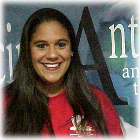


Hi there! My name is Jennifer Curtis. Having a deep love for the Antarctic, I
am eagerly awaiting my journey south! My interests in Antarctica began as I
read Alfred Lansing's book Endurance. This awesome account of Shackleton's
adventures stirred in me an intense longing to visit the continent. What once
seemed an impossible dream for me has now become very much a reality! I am so
fortunate! I can't wait!!
A lot of exciting things have been happening in my life lately! In January
of 2001 I finished my Masterąs Degree in School Administration. (What a
relief!!) In February I moved from Rhode Island to Washington State (a long
way!) to plan for my wedding and to get a head start in sharing my future
Antarctic travels with the students and community of Marysville, WA. In June
I married the most wonderful man in the world named Scott. We have lots of
fun playing with our Yellow Labrador named Jake (He weighs ninety pounds!)
and our two kitties named Molly and Sherman. Our house is a busy one!
This coming school year I will be working as a Science Specialist for grades
K-5 at Shoultes Elementary School in Marysville. I am looking forward to
teaching and getting to know all of the students at Shoultes! We are going to
have fun!
I am very excited to have been selected as a parcticipant in Teachers
Experiencing Antarctica and the Arctic. This opportunity will be a fantastic
learning experience for everyone. The on-going communication that I will have
with my students while I am in the field will give us all a chance to
experience the wonders and realities of Antarctica. I look forward to the
adventures that lie ahead!
TransAntarctic Mountains SEISmic Experiment (TAMSEIS), a broadband seismic experiment to investigate deep continental structure across the East-West Antarctic boundary.
Principal Investigators: Sridhar Anandakrishnan, University of Alabama; Andrew Nyblade, Penn State; Douglas Wiens, Washington University in St. Louis.
Antarctica in shape looks generally like Australia, though half again as large; but beneath its enormous ice sheet lays evidence of its origin. East Antarctica has a bedrock continent-like foundation, while the ice sheet over West Antarctica - a third the area - in fact covers a series of "islands". West Antarctica shares a geologic history with the South American Andes Mountains, the result of plates colliding and subducting. East Antarctica is more like a large coherent chunk that broke free of the supercontinent Gondwanaland and drifted to a new position at the bottom of the world. The boundary between these two regions is called the East-West Antarctic boundary, and the crust and upper mantle here reveal many important and interesting distinctions, which tell the basic story of the tectonic development of Antarctica.
This project will collect three years worth of seismic measurements - using three different arrays and a total of 44 seismic stations - all geared to evaluating geodynamic models of the evolution of Antarctica that rely on data about the crust and upper mantle. To analyze the data, a variety of proven modeling techniques will be used, including body- and surface-wave tomography (three-dimensional imaging), receiver function inversion, and shear-wave splitting analysis.
This project proposes to address two outstanding questions concerning the tectonic development of Antarctica:
1. How were the Transantarctic Mountains formed?
2. How did the structure of the East Antarctic craton (the highest ice block in the world) Arise? (A craton is a stable, relatively immobile area of the earth's crust that forms the nuclear mass of a continent or the central basin of an ocean.)
When completed and analyzed, this comprehensive set of data and theory testing will enable new maps to be made of the variation in crustal thickness, upper mantle structure, anisotropy (layering), and mantle discontinuity topography across the boundary of East and West Antarctica, providing a much enhanced foundation for understanding the geodynamics (the study of the processes in the earth's interior) of the Antarctic.
While I am in Antarctica I will be working with the TAMSEIS research team that will consist of about twelve members. During the first three weeks of November we will be stationed at McMurdo Base. Using helicopters and twin-engine Otter airplanes, we will fly up into the Transantarctic Mountains to install seismometers at various sites. Seismometers are instruments that detect vibrations in the ground. Back at the base we will collect and analyze data from these instruments. Around the fourth week in November, we will head to a remote field camp where we will live in tents for the next two weeks. We will be living at an altitude of about 9,000 feet. During our time in this field camp, we will continue our work of installing seismometers and collecting and analyzing data on the ice sheet.
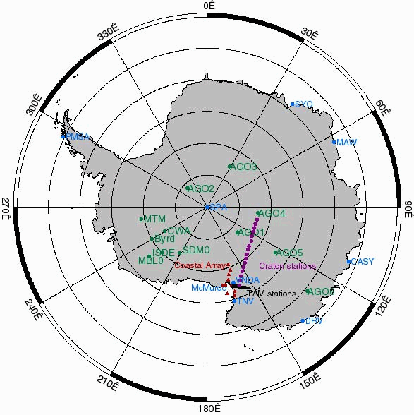
This map shows the various site locations for placement of TAMSEIS seismometers throughout Antarctica over the three-year period of the experiment.
Here is a summary of the project in a nutshell:
- The experiment will consist of the installation of seismometers throughout the Transantarctic region.
- The seismometers will enable the imaging of details of the crust and upper mantle structure across the East-West Antarctic boundary.
- Two questions to be addressed during the research:
1. How were the Transantarctic Mountains formed?
2. How did the structure of the East Antarctic craton arise?
- This experiment will be conducted over a three-year period to allow for sufficient data collection from naturally occurring earthquakes.
- Airborne surveys for surface elevation and ice thickness will be completed in support of this work.
- Data will be analyzed using a variety of proven modeling techniques.
- The results of these analyses will be used to create maps of the variation in crustal thickness, upper mantle structure, anisotropy, and mantle discontinuity topography across the boundary of East and West Antarctica.
- These results will provide a solid foundation for understanding the geodynamics of the Antarctic continent.
Links:
Special thanks to Sridhar Anandakrishnan and Doug Wiens for providing helpful information for this project description.
Be sure to check out the images in the journal entries!
December 2001
| Su |
Mo |
Tu |
We |
Th |
Fr |
Sa |
| -- |
-- |
-- |
-- |
-- |
-- |
1 |
| 2 |
3 |
4 |
5 |
6 |
7 |
8 |
| 9 |
10 |
11 |
12 |
13 |
14 |
15 |
| 16 |
17 |
18 |
19 |
20 |
21 |
22 |
| 23 |
24 |
25 |
26 |
27 |
28 |
29 |
| 30 |
31 |
-- |
-- |
-- |
-- |
-- |
November 2001
Return to top of page
|
